Approximate Location Map
Large Map »
Latitude: 51.5835 / 51°35'0"N
Longitude: -4.0421 / 4°2'31"W
OS Eastings: 258608
OS Northings: 189155
OS Grid: SS586891
Mapcode National: GBR GW.G3X2
Mapcode Global: VH4KF.WGGG
Plus Code: 9C3QHXM5+95
Entry Name: Murton Well
Listing Date: 29 September 1999
Last Amended: 29 September 1999
Grade: II
Source: Cadw
Source ID: 22375
Building Class: Religious, Ritual and Funerary
ID on this website: 300022375
Location: Situated on the Green, S of the community hall and E of the playground.
County: Swansea
Town: Swansea
Community: Bishopston (Llandeilo Ferwallt)
Community: Bishopston
Locality: Murton
Built-Up Area: Murton
Traditional County: Glamorgan
Tagged with: Well
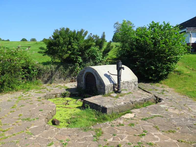
Murton Well is referred to as an ancient well associated with a former chapel. The brick vault of the structure suggests C19 restoration, whilst further work was undertaken in the mid C20.
The well is within a rectangular vaulted structure of rubble stone. Brick soffit to vault, probably C19, with rendered exterior. Round-headed entrance facing SW and containing an iron gate. The interior of the structure is white-washed. Water passes through a drain in the sill of the gateway into an irregular-shaped pool which curves round to the SE. The pool is surrounded by C20 crazy paving. Mounted against the SE side of the well is a cast iron water pump; cylindrical stem supports a narrow straight-sided fluted bowl with decorated spout and attached long handle.
Listed, not withstanding modern restoration, for its historic interest as a holy well of Wales.
External links are from the relevant listing authority and, where applicable, Wikidata. Wikidata IDs may be related buildings as well as this specific building. If you want to add or update a link, you will need to do so by editing the Wikidata entry.


Other nearby listed buildings
