Approximate Location Map
Large Map »
Latitude: 52.654 / 52°39'14"N
Longitude: -3.9378 / 3°56'15"W
OS Eastings: 269017
OS Northings: 308015
OS Grid: SH690080
Mapcode National: GBR 8Y.5YZ8
Mapcode Global: WH571.HK37
Plus Code: 9C4RM336+JV
Entry Name: Cedris
Listing Date: 10 April 2000
Last Amended: 10 April 2000
Grade: II
Source: Cadw
Source ID: 23201
Building Class: Domestic
ID on this website: 300023201
Location: Cedris is located on the valley floor, beside the Afon Dysynni, on the back road from Tal-y-llyn to Abergynolwyn.
County: Gwynedd
Town: Tywyn
Community: Llanfihangel-y-Pennant
Community: Llanfihangel-y-Pennant
Locality: Tal-y-llyn
Traditional County: Merionethshire
Tagged with: Farmhouse
The property originally known as Llangedrys appears first in the subsidy rolls of 1293 as one of the trefi of the district. The present house has clear early C17 origins, and was occupied by John Pughe whose will of 1782 survives. In 1838 tithe award the farm, owned by John Pugh, extended to 208 acres (84ha).
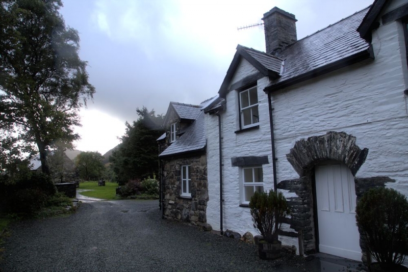
Built of irregular local slate rubble on boulder foundations, with a slate roof. One storey and attics, 3 bays, with a rear kitchen wing with its own gable stack, and outbuildings in line at the SE end. The front entrance is in the SW bay; a round-headed opening formed with long irregular slate voussoirs. Single light modern window to the left; and a large 3-light late C20 window to the right. The attic floor is lit by three 4-paned windows, rising through the eaves to small slated gables. All windows have dressed slate lintels. Splayed kneelers to the gables. Porch addition in the re-entrant angle and one roof light at the rear.
The house consists of a large living room occupying most of the NE half of the house, and, in the SW bay, a hallway and a narrow service room, now a parlour. The living room has a large gable-end fireplace with timber lintel, partly infilled, with a stone fire stair on the left, now walled in. The ceiling is divided into 6 panels by deep bar-stop chamfered ceiling beams and similar girth beams, the alternating panels having exposed joists rilled on their soffits, the other three underdrawn with plaster. The hallway has a continuation of the rilled cross joists, the stair, which rises from the hall, was replaced c1900 probably at the same time as the roof was renewed, probably at a raised level. The inner room or parlour has deep chamfered joists with bar stops. The main partitions are in their original positions. The small end parlour was probably originally unheated, and now has an inserted gable fireplace and stack. Door and step to the rear kitchen, which has a gable end fireplace with side oven
Included as a farmhouse of unusual plan, retaining its early C17 character in the arched doorway, and with a fire stair and important early ceiling and other features internally. A building where the detail suggests gentry status.
External links are from the relevant listing authority and, where applicable, Wikidata. Wikidata IDs may be related buildings as well as this specific building. If you want to add or update a link, you will need to do so by editing the Wikidata entry.


Other nearby listed buildings
