History in Structure

Milestone

A Grade II Listed Building in Pennal, Gwynedd

More Photos »
Approximate Location Map
Large Map »

Coordinates

Latitude: 52.591 / 52°35'27"N

Longitude: -3.8798 / 3°52'47"W

OS Eastings: 272754

OS Northings: 300905

OS Grid: SH727009

Mapcode National: GBR 91.9TLH

Mapcode Global: WH57G.C4PH

Plus Code: 9C4RH4RC+C3

Entry Name: Milestone

Listing Date: 25 May 2000

Last Amended: 25 May 2000

Grade: II

Source: Cadw

Source ID: 23341

Building Class: Transport

ID on this website: 300023341

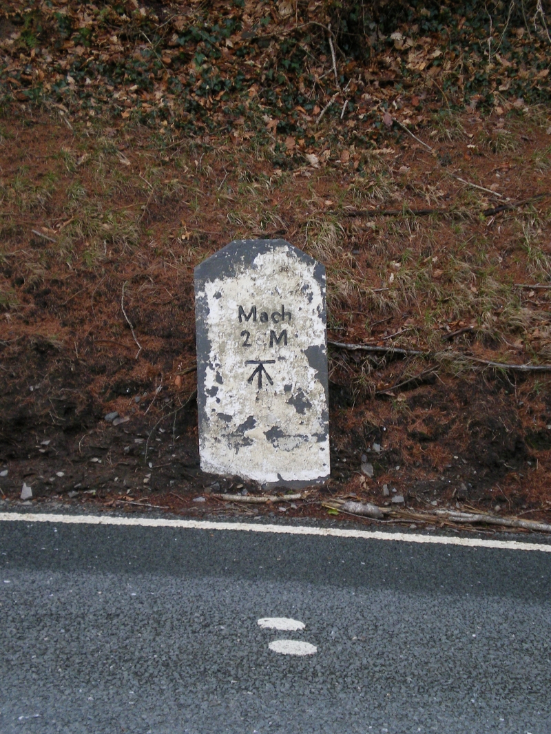
Location: The milestone is set in the verge of the road, as it climbs the bank running W from the turn to Dolygelynen farm.

County: Gwynedd

Town: Machynlleth

Community: Pennal

Community: Pennal

Locality: Penrhyn-Dyfi

Traditional County: Merionethshire

Tagged with: Milestone

Find accommodation in
Machynlleth

History

The milestone probably dates from the earlier calibration of the turnpike route from Machynlleth to Tywyn in the late C18.

Exterior

A very simple milestone consisting of a squared slab of stone with an angled top, whitewashed, and carrying the incised lettering Mach / 2 M. Below, a benchmark.

Reasons for Listing

Included as one of a series of simple turnpike milestones on the roads running W and N of the Pont-ar-ddyfi.

External Links

External links are from the relevant listing authority and, where applicable, Wikidata. Wikidata IDs may be related buildings as well as this specific building. If you want to add or update a link, you will need to do so by editing the Wikidata entry.

Recommended Books

Other nearby listed buildings

  • II Dolgelynen, including front garden walls
    The house is prominently sited on a bank, immediately overlooking the estuary of the River Dovey, with its farm buildings to the W. It is reached by a low level farm road leading off the A493 approxi
  • II Pant Lludw
    The house stands back in its own landscaped grounds in a secluded valley, c1200m W of Pont-ar-ddyfi, and is approached by a driveway from the W.
  • II Farm Range at Penrhyn-dyfi
    The range of farm buildings lies immediately W of the main house, and provides a wall to the front garden on this side.
  • II Pigsty Range at Penrhyn-dyfi
    The pigsty range is set at right angles at the N end of the long cowhouse range, NW of the house.
  • II Milestone
    The milestone is set back in the bank of the garden retaining wall of Penrhyn-Dyfi.
  • II Penrhyn-Dyfi
    The house stands prominently on a bank overlooking the road and the estuary of the Dovey, approximately 450m W of the Pont-ar-ddyfi.
  • II Gwerniago
    The house lies below the minor road from the A493, running S towards Llugwy Hall, and returning to Pennal village.
  • II Gates and Gatepiers at the SW Entry to Plas Machynlleth Park
    At right angles to Deildy (also known as West Lodge) at the SW end of the main drive to Plas Machynlleth. Attached to the boundary wall to left.

BritishListedBuildings.co.uk is an independent online resource and is not associated with any government department. All government data published here is used under licence. Please do not contact BritishListedBuildings.co.uk for any queries related to any individual listed building, planning permission related to listed buildings or the listing process itself.

British Listed Buildings is a Good Stuff website.