History in Structure

Cross in St James's Churchyard

A Grade II Listed Building in Grosmont, Monmouthshire

More Photos »
Approximate Location Map
Large Map »

Coordinates

Latitude: 51.9267 / 51°55'36"N

Longitude: -2.889 / 2°53'20"W

OS Eastings: 338968

OS Northings: 225729

OS Grid: SO389257

Mapcode National: GBR FC.NS02

Mapcode Global: VH78P.WT2V

Plus Code: 9C3VW4G6+MC

Entry Name: Cross in St James's Churchyard

Listing Date: 19 October 2000

Last Amended: 19 October 2000

Grade: II

Source: Cadw

Source ID: 24173

Building Class: Religious, Ritual and Funerary

ID on this website: 300024173

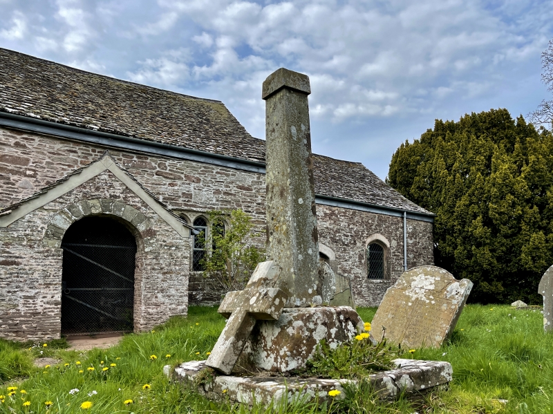
Location: In churchyard, some 5m S of the porch of the Church of St James, Llangua.

County: Monmouthshire

Town: Abergavenny

Community: Grosmont (Y Grysmwnt)

Community: Grosmont

Locality: Llangua

Traditional County: Monmouthshire

Tagged with: Christian cross

Find accommodation in
Grosmont

History

The remains of a medieval churchyard cross, probably C15.

Exterior

Red sandstone; cement rendered shaft. Base and C20 restored shaft of medieval churchyard cross, standing some 2m high; consisting of square base with two tiers of steps, square socket stone broaches to an octagon, tapering square shaft.

Reasons for Listing

Included as a medieval churchyard cross having group value with Church of St James.

External Links

External links are from the relevant listing authority and, where applicable, Wikidata. Wikidata IDs may be related buildings as well as this specific building. If you want to add or update a link, you will need to do so by editing the Wikidata entry.

Recommended Books

Other nearby listed buildings

  • II* Church of St James
    Located on the S bank of the River Monnow, at the end of a short track leading N off the A465, approximately 1km SW of Llangua Bridge.
  • II* Sleath Farmhouse (aka Lech Farmhouse)
    Located at the end of a short farm track which runs W off the minor road from Llangua to Grosmont, approximately 1 km S of Llangua Bridge.
  • II Barn at The Great House
    On steeply sloping ground on E side of minor road, some 500m S of the junction to Llangua on the A465. The barn lies opposite the farmhouse and encloses one side of farmyard.
  • II* The Great House
    On steeply sloping ground on E side of minor road, some 500m S of the A465 road junction to Llangua.
  • II Cider House and Cowhouse at The Great House
    Attached to N gable of Great House, on steeply sloping ground on E side of minor road, some 500m S of the A465 road junction to Llangua.
  • II Barn at Monmouth Cap
    Located at the end of a short field track on the SW side of the minor road from Llangua to Grosmont, approximately 600m SW of Llangua Bridge.
  • II Shelter Shed at Monmouth Cap
    Some 50m S of Monmouth Cap Farmhouse, reached by a short track off SW side of minor road from Llangua to Grosmont, approximately 600m SW of Llangua Bridge.
  • II Monmouth Cap Farmhouse
    Located at the end of a short farm track on the SW side of the minor road from Llangua to Grosmont, approximately 500m SW of Llangua Bridge.

BritishListedBuildings.co.uk is an independent online resource and is not associated with any government department. All government data published here is used under licence. Please do not contact BritishListedBuildings.co.uk for any queries related to any individual listed building, planning permission related to listed buildings or the listing process itself.

British Listed Buildings is a Good Stuff website.