Approximate Location Map
Large Map »
Latitude: 53.2493 / 53°14'57"N
Longitude: -3.2215 / 3°13'17"W
OS Eastings: 318594
OS Northings: 373174
OS Grid: SJ185731
Mapcode National: GBR 5ZYV.CX
Mapcode Global: WH76R.HL5C
Plus Code: 9C5R6QXH+PC
Entry Name: Lime Kilns at Bryn Mawr (Aberdo Quarry)
Listing Date: 30 November 2000
Last Amended: 30 November 2000
Grade: II
Source: Cadw
Source ID: 24445
Building Class: Industrial
ID on this website: 300024445
Location: Located off a track running N from the lane which links Pentre Halkyn and Babell. On the E side of the track and in a raised position, opposite Waen-Brodlas Farm.
County: Flintshire
Community: Brynford (Brynffordd)
Community: Brynford
Locality: Waen y Brodlas
Traditional County: Flintshire
Tagged with: Lime kiln
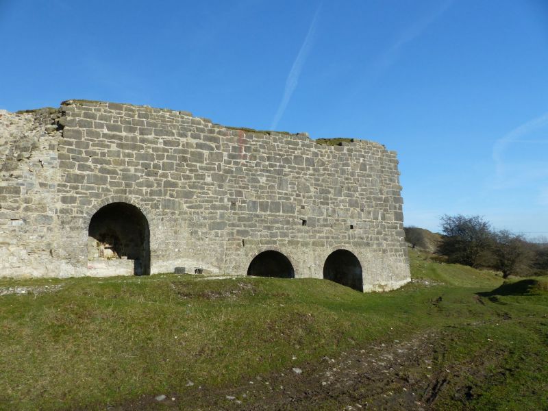
Bank of 5 limekilns from the mid C19; probably built in 3 phases. As early as 1796, Thomas Pennant had remarked that the local deep grey limestone was particularly suited for the manufacture of hydraulic cement (which dries under water), sometimes referred to as "Aberthaw" or "aberdo". The name is derived from Aberthaw in Glamorgan from where the engineer John Smeaton had sourced the basic material for the cement for his Eddystone lighthouse (completed 1759). hydraulic cement was naturally important in the building of docks, and bridges across stretches of water. This quarry, the principal aberdo quarry in Flintshire was worked in the early C19 by John Lloyd, and by 1862 by Lloyd Jones and Co. The lime was important in the construction of the docks at Liverpool and Birkenhead, and also Belfast, as well as bridges at Menai and Runcorn.
A bank of limekilns standing full-height and facing W, constructed of large blocks of grey stone. The 2nd kiln from the L appears to be the earliest; it is set back slightly and partially ruined. The voussoirs are missing but the stone soffit of the draw-hole tunnel is visible behind a pile of spoil. The shaft of the kiln is partly exposed and has a fire-brick lining. The 2 flanking kilns belong to the next phase, the face of the L kiln built at a slight angle to the rest. Both draw-hole tunnels have round-arched heads of stone voussoirs and stone soffits, with small flues to the rear retaining ironwork and under brick arched heads (partly missing). Domed brickwork above flue of R kiln. To the R of these kilns is a butt joint followed by a further pair of kilns which have wide brick arched heads to the draw-hole tunnels. The soffits are of brick supported on stone side walls. Each tunnel has a stone rear wall containing a flue with cast iron lintel and a pair of cast iron damper doors above.
The high tapering S end wall of the kilns has 2 cast iron tie plates, whilst the N end wall is stepped and partly eroded. On the upper level are fragments of a low rear wall. The tops of 3 shafts can be seen, all lined with brick.
Listed as a large well-preserved bank of quarry limekilns, in a prominent position and in their original context.
External links are from the relevant listing authority and, where applicable, Wikidata. Wikidata IDs may be related buildings as well as this specific building. If you want to add or update a link, you will need to do so by editing the Wikidata entry.


Other nearby listed buildings
