Latitude: 52.2031 / 52°12'11"N
Longitude: -3.7496 / 3°44'58"W
OS Eastings: 280530
OS Northings: 257535
OS Grid: SN805575
Mapcode National: GBR Y6.38LD
Mapcode Global: VH5CY.YWLH
Plus Code: 9C4R6732+65
Entry Name: Nant Ystalwyn
Listing Date: 19 January 2001
Last Amended: 19 January 2001
Grade: II
Source: Cadw
Source ID: 24524
Building Class: Domestic
ID on this website: 300024524
Location: Located in mountainous terrain along a track which runs N off the Abergwesyn to Tregaron road. The house faces the River Towy to the W and is built parallel with it.
County: Powys
Town: Builth Wells
Community: Llanwrtyd Wells (Llanwrtyd)
Community: Llanwrtyd Wells
Locality: Nant y Stalwyn
Traditional County: Brecknockshire
Tagged with: House
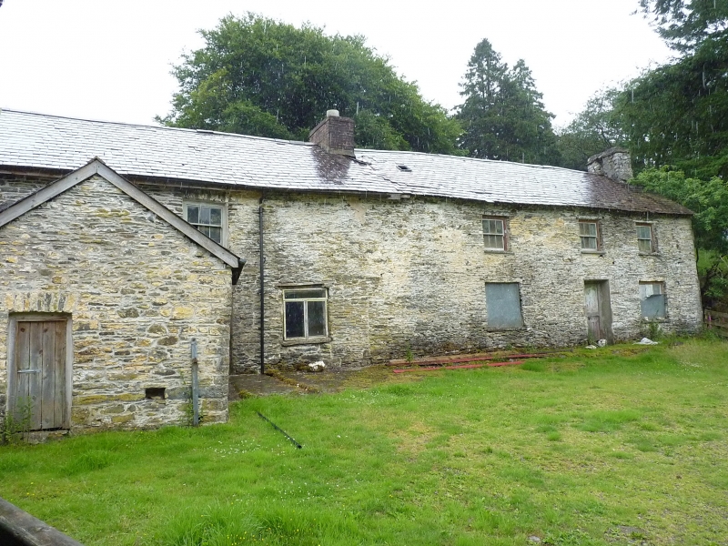
A large early C19 farmhouse in an upland setting, reflecting a change from mixed farming to specialist sheep rearing. The house had a central stair-hall arrangement with hall to L and parlour to R. The long adjoining service unit or 'back-kitchen' to the L is contemporary and there is no division.
Long 2-storey range with house to R end and service unit to L. Small adjoining bakehouse at right angles to far L. Constructed of rubble stone under a slate roof with projecting stone stack to R end and brick ridge stack to centre. Small skylight to roof pitch. The house at the R end is 3-window, the central openings offset slightly to the R. The entrance contains a half-glazed planked door, the light boarded over. The flanking windows are also boarded, although that to the R is partly visible as a sash. The openings all have flat heads and stone sills. Those to the upper storey are 3-over-3-pane horned sashes, that to the L boarded over, and aligned with the openings below. To the L of the brick stack is the joint of a former doorway, L of which is a late C20 window. Further L, in the angle with the bakehouse, is a planked door under a shallow segmental head of stone voussoirs. Above is a 3-over-3-pane horned sash under a similar head. The single-storey bakehouse has a stone ridge stack offset to the L. Planked door offset to the R, rising to the eaves, and signs of alterations towards the centre of the wall. Opening to gable end offset to the L. The rear of the house is cut into the hillside, but has a 4-pane window to the upper storey towards the centre of the house part, which must light the stairs.
No access to interior at time of inspection.
Listed as a rare and unaltered example of an upland farmhouse built for a specialist sheep farmer, which marks an important change from the long-house tradition.
External links are from the relevant listing authority and, where applicable, Wikidata. Wikidata IDs may be related buildings as well as this specific building. If you want to add or update a link, you will need to do so by editing the Wikidata entry.