History in Structure

Signpost Penalt/Trelleck

A Grade II Listed Building in Trellech United (Tryleg Unedig), Monmouthshire

More Photos »
Approximate Location Map
Large Map »

Coordinates

Latitude: 51.7637 / 51°45'49"N

Longitude: -2.7104 / 2°42'37"W

OS Eastings: 351068

OS Northings: 207465

OS Grid: SO510074

Mapcode National: GBR JK.04XZ

Mapcode Global: VH870.YXZT

Plus Code: 9C3VQ77Q+FR

Entry Name: Signpost Penalt/Trelleck

Listing Date: 28 February 2001

Last Amended: 28 February 2001

Grade: II

Source: Cadw

Source ID: 24944

Building Class: Transport

ID on this website: 300024944

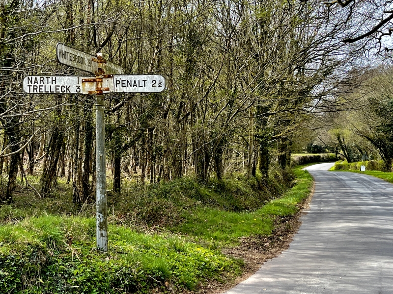
Location: On the south side of the Whitebrook valley road and about 2500m west of the Church of the Holy Trinity. It is at the crossroads for Whitebrook, Penallt, Monmouth and The Narth.

County: Monmouthshire

Town: Monmouth

Community: Trellech United (Tryleg Unedig)

Community: Trellech United

Locality: Whitebrook

Traditional County: Monmouthshire

Tagged with: Signpost

Find accommodation in
Mitchel Troy

History

A Monmouthshire County Council signpost of the type erected following the County Councils taking over responsibility for roads after the 1888 County Councils Act. It was probably erected in the early C20.

Exterior

Cast iron sign post with four arms. The post is a fluted Doric column which supports two arms with raised lettering PENALT 2 I/2 and NARTH 1 TRELLECK 3. Above these are two more WHITEBROOK 1 3/4 and MONMOUTH 5. The post is topped by a vertical ring inscribed MONMOUTHSHIRE COUNTY COUNCIL.

Reasons for Listing

Included as an unaltered probably early C20 Monmouthshire County Council signpost. Now extremely rare in unaltered state.

External Links

External links are from the relevant listing authority and, where applicable, Wikidata. Wikidata IDs may be related buildings as well as this specific building. If you want to add or update a link, you will need to do so by editing the Wikidata entry.

Recommended Books

Other nearby listed buildings

  • II Fernside Mill
    On the north side of the Whitebrook valley road and about 2km west of the Church of the Holy Trinity.
  • II Gardener's Cottage at High Glanau
    Above and to NE of the house which is set in its own wooded grounds. The cottage lies between the upper and lower drives.
  • II* High Glanau
    Off the W side of the road, approached along a wooded drive on Trellech Hill, and set in its own grounds. On a levelled site with sloping lawns to either side and spectacular views to west.
  • II Garage at High Glanau
    Approached down wooded drive; the house is set in its own grounds. To NE of house.
  • II Greenhouse at High Glanau
    Approximately 5m S of Garden Wall to S of High Glanau
  • II* Terraces at High Glanau
    Off the W side of the road, approached along a wooded drive on Trellech Hill, immediately on the W side of the house.
  • II Garden Wall and Pergola at High Glanau
    To S of the house reached along a broad, tree-lined path, formerly with herbaceous borders, divides the lawns and informal gardens from the kitchen garden and greenhouses.
  • II Glanau Farm, Barn to S of
    About 20m S of Glanau Farmhouse, in an elevated position on the W facing slope of hills overlooking Cwmcarvan; reached by a track which runs S past High Glanau and then angles back sharply northward,

BritishListedBuildings.co.uk is an independent online resource and is not associated with any government department. All government data published here is used under licence. Please do not contact BritishListedBuildings.co.uk for any queries related to any individual listed building, planning permission related to listed buildings or the listing process itself.

British Listed Buildings is a Good Stuff website.