Approximate Location Map
Large Map »
Latitude: 51.826 / 51°49'33"N
Longitude: -2.7482 / 2°44'53"W
OS Eastings: 348531
OS Northings: 214413
OS Grid: SO485144
Mapcode National: GBR FJ.W4YC
Mapcode Global: VH86T.9CZK
Plus Code: 9C3VR7G2+9P
Entry Name: Gateway next to Monmouth Lodge
Listing Date: 19 March 2001
Last Amended: 19 March 2001
Grade: II
Source: Cadw
Source ID: 25053
Building Class: Gardens, Parks and Urban Spaces
ID on this website: 300025053
Location: At the entrance to the drive to Rockfield House, approximately 200m SE of the centre of Rockfield village.
County: Monmouthshire
Town: Monmouth
Community: Llangattock-Vibon-Avel (Llangatwg Feibion Afel)
Community: Whitecastle
Locality: Rockfield
Traditional County: Monmouthshire
Tagged with: Gate
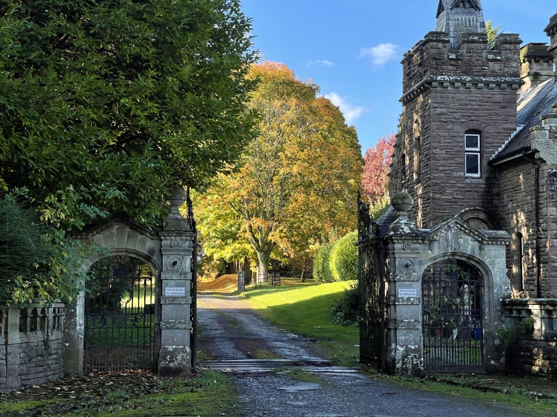
Probably contemporary with the associated lodge dated 1896; and perhaps also designed by Aston Webb.
A carriage gateway with flanking pedestrian gates and attached side walls. Dressed stone with wrought-iron gates. A pair of square gate piers approximately 3m high, with chamfered corners, banded rustication, dentilled cornices and swept caps with ball finials. Attached to the outer side of each is a short screen wall with a segmental-arched pedestrian gateway with 2 orders of moulding and a dentilled gabled parapet. The main gateway is furnished with a pair of large barred gates with heraldic ornament in the centre including the monogram "Ll" and very elaborate scrolled cresting. The pedestrian gateways each have a single barred gate with dogbars, a band of scrolled circles and lyre-shaped enrichment to the upper panels. Attached to the front face of each screen wall is a low convex quadrantal balustraded side wall.
Included as a fine gateway which forms a group with Monmouth Lodge, and is one of a series of good late C19 structures associated with The Hendre.
External links are from the relevant listing authority and, where applicable, Wikidata. Wikidata IDs may be related buildings as well as this specific building. If you want to add or update a link, you will need to do so by editing the Wikidata entry.


Other nearby listed buildings
