Latitude: 53.2755 / 53°16'31"N
Longitude: -3.26 / 3°15'36"W
OS Eastings: 316076
OS Northings: 376134
OS Grid: SJ160761
Mapcode National: GBR 5ZPK.0J
Mapcode Global: WH76J.WXSS
Plus Code: 9C5R7PGQ+6X
Entry Name: Chapel of the Sepulchre, including walls flanking entrance
Listing Date: 25 May 2001
Last Amended: 25 May 2001
Grade: II
Source: Cadw
Source ID: 25254
Building Class: Religious, Ritual and Funerary
ID on this website: 300025254
Location: Located to the N of Pantasaph Friary and reached by a path which zig-zags up the hill following the stations of the cross. Located close to the summit, in front of the Calvary, and built into the slo
County: Flintshire
Town: Holywell
Community: Whitford (Chwitffordd)
Community: Whitford
Locality: Pantasaph
Traditional County: Flintshire
Tagged with: Chapel
The Church of St David, begun in 1849 to the design of T H Wyatt, was built by Lord and Lady Fielding in honour of their marriage. A year later, the church became Roman Catholic on the conversion of the donors. Lord and Lady Fielding established a community of Franciscan Friars of the Capuchin reform in 1852, and the friary buildings were completed in the early 1860s.
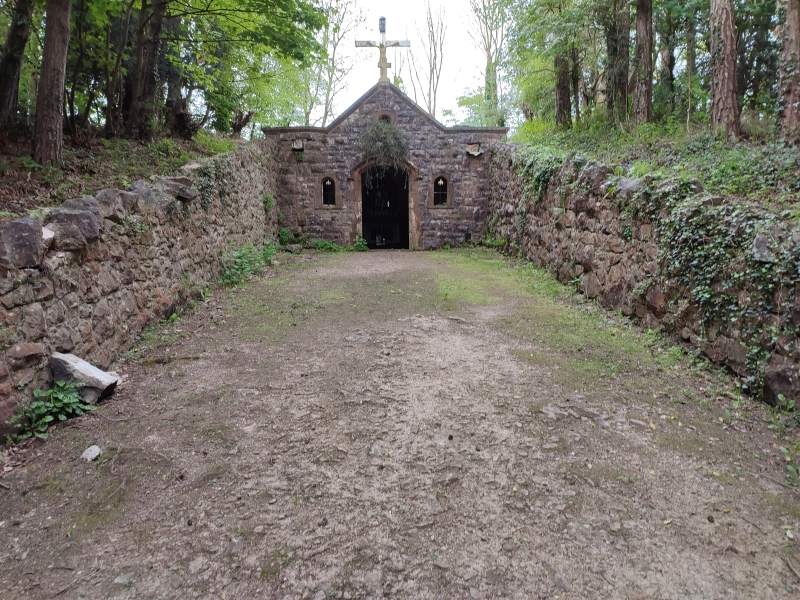
The chapel is located at the end of the Way of the Cross, a path which zig-zags up the hillside passing tiny chapels containing the stations of the cross. This larger chapel contains the last (14th) station, and they were all built by the brothers in 1875. The depictions, originally in stone relief, were replaced by mosaics in the 1960s. The chapel has been used for Mass and Benediction on festival days.
Rectangular single-cell chapel with gable-end facade constructed of snecked rock-faced stone with red sandstone dressings. Pitched slate-covered roof, the rear and side walls below ground level. Wide gutters to eaves, to drain water towards the S, which are bounded by low rubble stone walls with stepped flat coping stones. The front is symmetrical with central entrance. Chamfered doorway with decorative filleted stops and a segmental-arched head under a hoodmould. This is flanked by small single lights with shallow pointed-arched heads and stone sills, which contain substantial iron cross-bars, each with a fleur-de-lis finial. Above the entrance is a small chamfered roundel in a square surround under a relieving arch. Cross to gable apex. The gable is flanked by parapets, all of which have continuous moulded stone copings. Beneath the parapets to each side, is a small opening for draining water from the eaves. The entrance is approached by a sunken walkway of similar width to the chapel, which is retained by rubble stone walls with rough stone copings.
The interior has a canted plaster ceiling, encaustic tile floor, brick-lined walls and small decorative iron vents. Towards the N end is an almost full-height chamfered stone arch with hollow stops with fillets, and a hoodmould with scrolled foliate end stops. The archway contains double decorative iron gates with arched head, fleur-de-lis and scrolled finials, and flanking railings with pointed finials. Small sanctuary behind arch containing a dressed stone altar. Reredos with a trefoil-headed blind arch containing the 14th station, in the form of a coloured mosaic entitled 'Jesus is laid in the tomb'. A stone tablet under the altar is a memorial to Francis W Reynolds, who erected this station, and to the other benefactors of the chapel. Above the archway is an iron vent in the shape of a cross.
Listed as an unaltered and unusual religious building reflecting an important Roman Catholic tradition and for group value with friary and Church of St David.
External links are from the relevant listing authority and, where applicable, Wikidata. Wikidata IDs may be related buildings as well as this specific building. If you want to add or update a link, you will need to do so by editing the Wikidata entry.


Other nearby listed buildings