History in Structure

Cross in churchyard of the church of St Dingat

A Grade II Listed Building in Mitchel Troy, Monmouthshire

More Photos »
Approximate Location Map
Large Map »

Coordinates

Latitude: 51.7895 / 51°47'22"N

Longitude: -2.7884 / 2°47'18"W

OS Eastings: 345718

OS Northings: 210392

OS Grid: SO457103

Mapcode National: GBR FH.YDYZ

Mapcode Global: VH79J.M87Z

Plus Code: 9C3VQ6Q6+RJ

Entry Name: Cross in churchyard of the church of St Dingat

Listing Date: 27 September 2001

Last Amended: 27 September 2001

Grade: II

Source: Cadw

Source ID: 25778

Building Class: Religious, Ritual and Funerary

ID on this website: 300025778

Location: About 10m S of the church.

County: Monmouthshire

Town: Monmouth

Community: Mitchel Troy (Llanfihangel Troddi)

Community: Mitchel Troy

Locality: Dingestow

Traditional County: Monmouthshire

Tagged with: Christian cross

Find accommodation in
Penrhôs

History

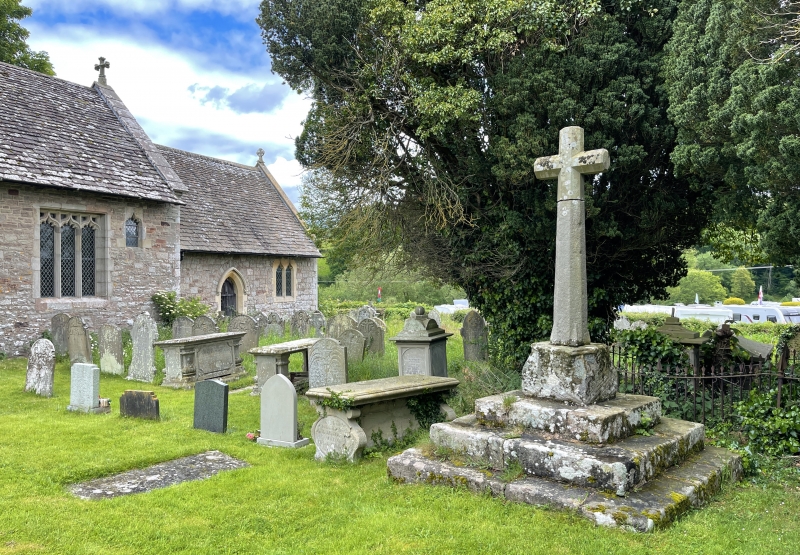
Base perhaps late-medieval; restored cross probably late C19.

Exterior

The stepped base and pedestal of a churchyard cross. Built of large roughly-dressed blocks of sandstone. About 2m square, with 3 steps up to a pedestal with large broach stops to the corners. Simple restored cross, chamfered, with broach stops to the foot.

Reasons for Listing

Included for group value with the church.

External Links

External links are from the relevant listing authority and, where applicable, Wikidata. Wikidata IDs may be related buildings as well as this specific building. If you want to add or update a link, you will need to do so by editing the Wikidata entry.

Recommended Books

Other nearby listed buildings

  • II* Church of St Dingat
    About 5km WSW of Monmouth, on the N side of the junction of four minor roads, and close to the E side of the earthworks marking the site of Dingestow Castle.
  • II Range of farm buildings at Tre-Owen Farm
    About 4.5km WSW of Monmouth and 1km NNE of Dingestow church, on the E side of the track leading to Tre-Owen and about 50m SW of the house.
  • I Tre-Owen
    About 4.5km WSW of Monmouth and 1km NNE of Dingestow church, prominently situated amidst its own parkland about ¾km N of the minor road between Dingestow and Wonastow.
  • II* Dingestow Court
    Standing in its own grounds, about 1km SW of the church of St Dingat.
  • II Seddon House School at Dingestow Court
    On the N side of the W courtyard at Dingestow Court
  • II Former stable block at Dingestow Court
    On the W side of the stable courtyard at Dingestow Court.
  • II Fishpool Farmhouse: front range
    About 1km WSW of the church of St Dingat, at the top of a farm track off the N side of the minor road between Dingestow and Tregare to the N of Dingestow Court
  • II Fishpool Farmhouse: rear range
    About 1km WSW of the church of St Dingat, at the top of a farm track off the N side of the minor road between Dingestow and Tregare to the N of Dingestow Court

BritishListedBuildings.co.uk is an independent online resource and is not associated with any government department. All government data published here is used under licence. Please do not contact BritishListedBuildings.co.uk for any queries related to any individual listed building, planning permission related to listed buildings or the listing process itself.

British Listed Buildings is a Good Stuff website.