Approximate Location Map
Large Map »
Latitude: 51.5917 / 51°35'29"N
Longitude: -3.3234 / 3°19'24"W
OS Eastings: 308417
OS Northings: 188920
OS Grid: ST084889
Mapcode National: GBR HR.BSX1
Mapcode Global: VH6DR.B8W5
Plus Code: 9C3RHMRG+MJ
Entry Name: Treforest Tinplate Works Feeder Sluice and Weir
Listing Date: 15 September 2003
Last Amended: 15 September 2003
Grade: II
Source: Cadw
Source ID: 80670
Building Class: Industrial
ID on this website: 300080670
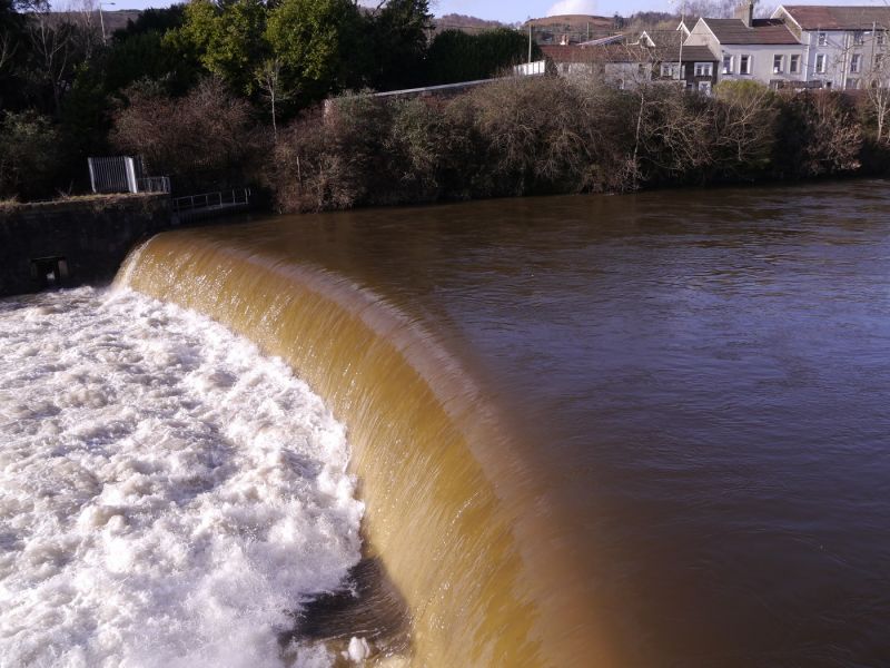
Location: A spectacular crescent-shaped weir curving across River Taff just below Castle Bridge. The structures for the sluice are on the W bank.
County: Rhondda Cynon Taff
Town: Pontypridd
Community: Pontypridd
Community: Pontypridd
Locality: Treforest
Built-Up Area: Pontypridd
Traditional County: Glamorgan
Tagged with: Architectural structure
Treforest Tinplate Works was rebuilt 1834-5 by the Cyfarthfa Iron Co, at that time one of the largest industrial concerns in Britain with its ironworks in Merthyr Tydfil. Its erection also coincided with the accelerated growth of the British tinplate industry that continued throughout the remainder of the C19. From the beginning waterwheels were the principal motive power at the works. The weir is dated 1834-5 and is shown on the 1846 Tithe map, but the present sluice may be later, and is shown on the 1881 Ordnance Survey. The continued use of water power in the age of steam was characteristic of the Cyfarthfa Iron Co and was made possible by the unusual reliability of the water supply in Glamorgan. The tinplate works closed in 1939. Modern structures for a fish pass have been added (2003) behind the main walls of the sluice.
The sluice is on the W side of the weir. It has coursed, rubble stone N wall formerly with 2 cast iron sluice gates on the upstream side, now with concrete cappings, metal railings and modern grilles at water level. On the opposite side of the wall is part of a cast iron lintel supported by 2 uprights, through which the water flowed. On the E side is a wall of coursed rubble with rock-faced quoins and dressings. Within a splayed recess is the cast iron frame and lifting rack of a former sluice, downstream from the weir, the purpose of which was the return of water to the river. The concrete block walls of fish pass are topped by metal railings and step down behind the original walls of sluice. Modern sluice gates.
Downstream is an abutting rubble stone river wall but the original watercourse is no longer clearly defined. The masonry weir is curved into the current.
Listed for industrial archaeological interest as a well-preserved group of C19 structures associated with water power for large-scale industry, and as an integral component of the Treforest Tinplate Works, one of the most complete surviving groups of tinplate works buildings of the C19.
External links are from the relevant listing authority and, where applicable, Wikidata. Wikidata IDs may be related buildings as well as this specific building. If you want to add or update a link, you will need to do so by editing the Wikidata entry.


Other nearby listed buildings
