Approximate Location Map
Large Map »
Latitude: 52.9432 / 52°56'35"N
Longitude: -3.9907 / 3°59'26"W
OS Eastings: 266326
OS Northings: 340273
OS Grid: SH663402
Mapcode National: GBR 5W.LP2F
Mapcode Global: WH55N.N9V1
Plus Code: 9C4RW2V5+7P
Entry Name: Haybarn opposite Derlwyn
Listing Date: 25 February 2005
Last Amended: 25 February 2005
Grade: II
Source: Cadw
Source ID: 84003
Building Class: Agriculture and Subsistence
ID on this website: 300084003
Location: Set below the N side of the A496 leading SE out of the village of Maentwrog towards Harlech; directly opposite Derllwyn.
County: Gwynedd
Community: Maentwrog
Community: Maentwrog
Traditional County: Merionethshire
Tagged with: Hay barn
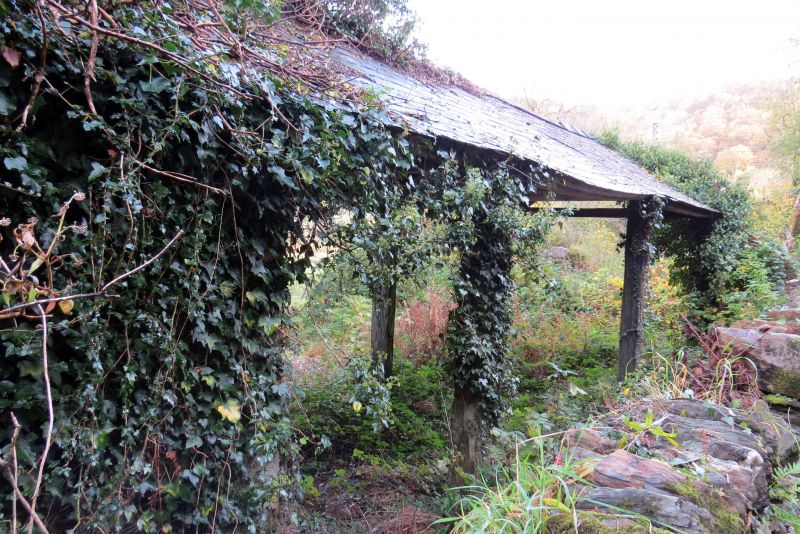
Probably mid to late C19 haybarn of characteristic regional type.
C19 haybarn with a mortared rubble wall at the L (W) gable; slate roof on open lateral walls and opposite gable supported on stone slab piers.
Listed as a good example of this building type which is especially characteristic of this area. Forms a group with the adjacent cottage(s) at Derllwyn.
External links are from the relevant listing authority and, where applicable, Wikidata. Wikidata IDs may be related buildings as well as this specific building. If you want to add or update a link, you will need to do so by editing the Wikidata entry.


Other nearby listed buildings
