History in Structure

Milestone

A Grade II Listed Building in Llangurig, Powys

More Photos »
Approximate Location Map
Large Map »

Coordinates

Latitude: 52.4063 / 52°24'22"N

Longitude: -3.6057 / 3°36'20"W

OS Eastings: 290863

OS Northings: 279916

OS Grid: SN908799

Mapcode National: GBR 9D.PGX3

Mapcode Global: VH5C2.GS45

Plus Code: 9C4RC94V+GP

Entry Name: Milestone

Listing Date: 24 March 2005

Last Amended: 24 March 2005

Grade: II

Source: Cadw

Source ID: 84298

ID on this website: 300084298

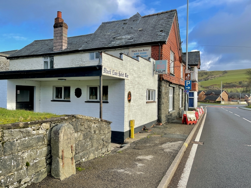
Location: In the centre of the village, on the N side of the main road, immediately R of the water-fountain.

County: Powys

Community: Llangurig

Community: Llangurig

Traditional County: Montgomeryshire

Tagged with: Milestone

Find accommodation in
Llangurig

History

C19 milestone associated with the turnpiking of this strategic E-W route.

Exterior

Stone pillar with arched head, bearing inscribed writing painted black. Around the arched head it reads 'Llanidloes', and under the arch, ' 5 / miles / Aberystwyth / 24.5 miles'. An iron plate was formerly fixed to the front, only the bolts remaining.

Reasons for Listing

Listed as a well-preserved C19 milestone, one of the few to survive completely on this stretch of road. Group value with the water-fountain and other structures in the village.

External Links

External links are from the relevant listing authority and, where applicable, Wikidata. Wikidata IDs may be related buildings as well as this specific building. If you want to add or update a link, you will need to do so by editing the Wikidata entry.

Recommended Books

Other nearby listed buildings

  • II Memorial Fountain
    On the N side of the main road in the centre of Llangurig, to the E of the church. Flanked by low rubble walls retaining the village green.
  • II Memorial to Chevalier Lloyd
    In the centre of the village. Located on the pavement, immediately E of the lychgate.
  • II Former Coach-house at Penybont
    In Llangurig, to the E of the church; close to the junction between the by-road to the S and the main A44. It is at right angles to the rear of Penybont to which it is linked by a stone wall with rou
  • II Lychgate at Church of St Curig
    On the S side of the A44 and forming the main entrance to the church.
  • II Penybont & Glanyrafon, including forecourt wall
    In Llangurig, to the E of the church, at the side of the by-road that runs S along the Wye Valley; immediately below the junction with the main A44. Penybont fronts the road and Glanyrafon is at right
  • II The Blue Bell Inn
    Fronting the N side of the main road, opposite the church. It is at the junction with a by-road which runs N towards Llanidloes.
  • II No.1
    On the W side of a by-road which runs N towards Llanidloes, and close to the junction with the main A44.
  • II No.2
    On the W side of a by-road which runs N towards Llanidloes, and close to the junction with the main A44.

BritishListedBuildings.co.uk is an independent online resource and is not associated with any government department. All government data published here is used under licence. Please do not contact BritishListedBuildings.co.uk for any queries related to any individual listed building, planning permission related to listed buildings or the listing process itself.

British Listed Buildings is a Good Stuff website.