Approximate Location Map
Large Map »
Latitude: 53.2669 / 53°16'0"N
Longitude: -4.0953 / 4°5'43"W
OS Eastings: 260352
OS Northings: 376478
OS Grid: SH603764
Mapcode National: GBR JN82.0SW
Mapcode Global: WH542.243W
Plus Code: 9C5Q7W83+PV
Entry Name: Boundary stone on Henllys Lane
Listing Date: 13 July 2005
Last Amended: 13 July 2005
Grade: II
Source: Cadw
Source ID: 84758
ID on this website: 300084758
Location: On the E side of the road approximately 200m N of the junction with Wexham Street.
County: Isle of Anglesey
Town: Beaumaris
Community: Beaumaris (Biwmares)
Community: Beaumaris
Built-Up Area: Beaumaris
Traditional County: Anglesey
Tagged with: Boundary marker
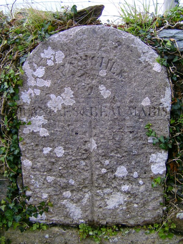
Probably c1863, the date of a similar stone at the N end of Llanfaes parish.
A round-headed roadside marker, with weathered inscription. In the centre is 'parishes', above a vertical dividing line which reads 'Llanfaes' on the L and 'Beaumaris' on the R.
Listed for its special historical interest as one of a series of C19 stones of definite character that mark the boundary of Llanfaes parish.
External links are from the relevant listing authority and, where applicable, Wikidata. Wikidata IDs may be related buildings as well as this specific building. If you want to add or update a link, you will need to do so by editing the Wikidata entry.


Other nearby listed buildings
