Approximate Location Map
Large Map »
Latitude: 51.5195 / 51°31'10"N
Longitude: -2.2014 / 2°12'5"W
OS Eastings: 386119
OS Northings: 180086
OS Grid: ST861800
Mapcode National: GBR 1Q9.N87
Mapcode Global: VH963.S2KG
Plus Code: 9C3VGQ9X+RC
Entry Name: The Barton
Listing Date: 20 December 1960
Last Amended: 29 February 1988
Grade: II
Source: Historic England
Source ID: 1022304
English Heritage Legacy ID: 315867
ID on this website: 101022304
Location: Grittleton, Wiltshire, SN14
County: Wiltshire
Civil Parish: Grittleton
Traditional County: Wiltshire
Lieutenancy Area (Ceremonial County): Wiltshire
Church of England Parish: Grittleton and Leigh Delamere
Church of England Diocese: Bristol
Tagged with: Building
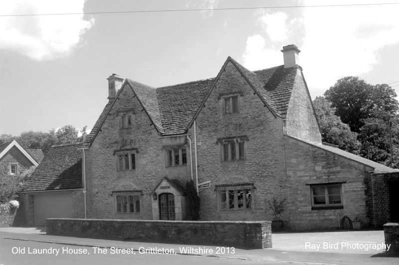
GRITTLETON THE STREET
ST 88 SE (south side)
3/56 The Barton
(formerly listed as Cottage 110 yds
20.12.60 NE of Church)
GV II
House, later C17, rubble stone with stone slate roof and end
stacks. 2½ storeys, 3-window range with regular 2-gabled front and
ovolo-moulded mullion windows with hoodmoulds, two 2-lights to
attic, three 3-light to first floor and 2-four lights to ground
floor with king mullions. Main windows have relieving arches.
Centre shallow-gabled ashlar porch with depressed-arched opening.
C20 additions each end.
Listing NGR: ST8611980085
External links are from the relevant listing authority and, where applicable, Wikidata. Wikidata IDs may be related buildings as well as this specific building. If you want to add or update a link, you will need to do so by editing the Wikidata entry.


Other nearby listed buildings
