Approximate Location Map
Large Map »
Latitude: 51.6466 / 51°38'47"N
Longitude: -1.9361 / 1°56'9"W
OS Eastings: 404517
OS Northings: 194198
OS Grid: SU045941
Mapcode National: GBR 3RR.PBN
Mapcode Global: VHB2Y.DW93
Plus Code: 9C3WJ3W7+JH
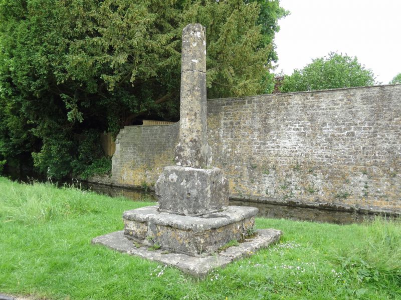
Entry Name: Wayside Cross by Gumstool Bridge
Listing Date: 17 January 1955
Grade: II
Source: Historic England
Source ID: 1023058
English Heritage Legacy ID: 317678
ID on this website: 101023058
Location: Ashton Keynes, Wiltshire, SN6
County: Wiltshire
Civil Parish: Ashton Keynes
Built-Up Area: Ashton Keynes
Traditional County: Wiltshire
Lieutenancy Area (Ceremonial County): Wiltshire
Church of England Parish: Ashton Keynes
Church of England Diocese: Bristol
Tagged with: Wayside cross
SU 09 SW ASHTON KEYNES CHURCH WALK
(south side)
10/29 Wayside cross by Gumstool Bridge
7.1.55
GV II
Cross. C14 or C15. Limestone. Base and single step with nosing.
Cross base square reducing to octagon and large stops in angles.
Top recessed, carrying tapered octagonal cross shaft broken above
2m height. (Ancient Monument No.293)
Listing NGR: SU0451794198
External links are from the relevant listing authority and, where applicable, Wikidata. Wikidata IDs may be related buildings as well as this specific building. If you want to add or update a link, you will need to do so by editing the Wikidata entry.


Other nearby listed buildings
