Approximate Location Map
Large Map »
Latitude: 51.6142 / 51°36'51"N
Longitude: -1.8796 / 1°52'46"W
OS Eastings: 408429
OS Northings: 190608
OS Grid: SU084906
Mapcode National: GBR 3S6.RLG
Mapcode Global: VHB35.CPND
Plus Code: 9C3WJ47C+M4
Entry Name: Salt's Hole
Listing Date: 17 April 1986
Grade: II
Source: Historic England
Source ID: 1023187
English Heritage Legacy ID: 317986
ID on this website: 101023187
Location: Purton Stoke, Wiltshire, SN5
County: Wiltshire
Civil Parish: Purton
Traditional County: Wiltshire
Lieutenancy Area (Ceremonial County): Wiltshire
Church of England Parish: Purton
Church of England Diocese: Bristol
Tagged with: Building
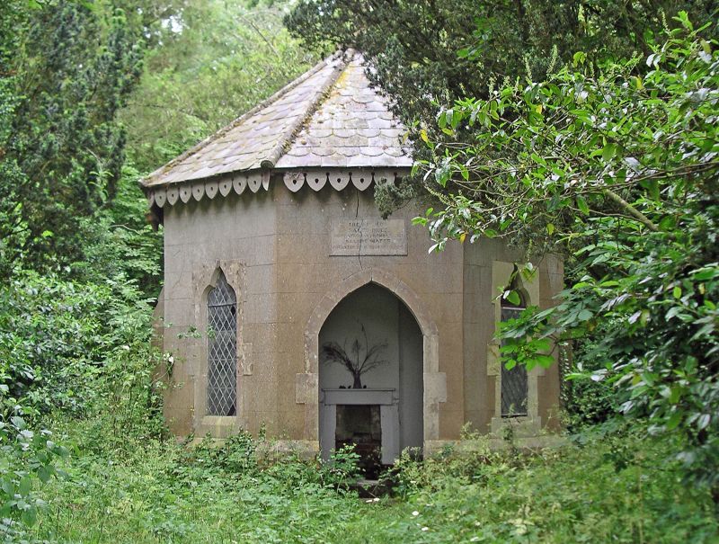
SU 09 SE PURTON STOKE COMMON LANE
Purton Stoke
8/341 Salt's Hole
II
Salt spring well house, 1859. Brick, rendered and lined as ashlar above
brick plinth. slate roof. Octagonal, with small side buttresses. Central
door with 2-centred arch and trefoil headed windows either side, all with
ashlar surrounds. Carved bargeboards with timber pendents at angles.
Apex of roof has a turned wood finial. Interior has simple fireplace on back
wall and plaster flat ceiling. To rear, two 2-light windows above ceiling.
Well in centre with iron-bound stone capping. Inscription over door reads:
THE ANCIENT /SALT'S HOLE/SULPHATED AND BROMO-IODATED/SALINE WATER/ANALYSED BY
D VOELKER 1860. This building, and the adjoining Spa Cottage at Purton based
on this saline spring rich in phosphate of lime. (Reference: Richardson,
M S. The Storey of Purton, 1919).
Listing NGR: SU0842990608
External links are from the relevant listing authority and, where applicable, Wikidata. Wikidata IDs may be related buildings as well as this specific building. If you want to add or update a link, you will need to do so by editing the Wikidata entry.


Other nearby listed buildings
