Approximate Location Map
Large Map »
Latitude: 50.9929 / 50°59'34"N
Longitude: -1.7418 / 1°44'30"W
OS Eastings: 418217
OS Northings: 121532
OS Grid: SU182215
Mapcode National: GBR 528.QFP
Mapcode Global: FRA 767H.982
Plus Code: 9C2WX7V5+57
Entry Name: 27 and 29, High Street
Listing Date: 4 July 1985
Grade: II
Source: Historic England
Source ID: 1023893
English Heritage Legacy ID: 319652
ID on this website: 101023893
Location: Downton, Wiltshire, SP5
County: Wiltshire
Civil Parish: Downton
Built-Up Area: Downton
Traditional County: Wiltshire
Lieutenancy Area (Ceremonial County): Wiltshire
Church of England Parish: Downton St Lawrence
Church of England Diocese: Salisbury
Tagged with: Building
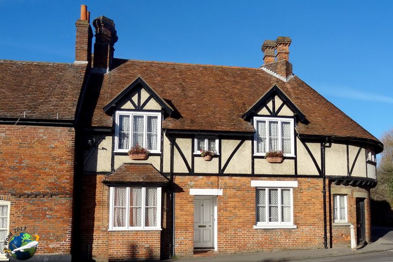
DOWNTON HIGH STREET
SU 1821
(north side)
6/93
Nos 27 and 29
GV II
Pair of houses at end of row, late C19. Flemish bond brick, with
some timber-framing to first floor, tiled roof, brick stacks. L-
plan, on corner. One storey and attic, 3 windows. 4-panelled
doors, to No. 27 in recessed porch to left, No. 29 has door on
curved corner; header bond brick, 3-light square bay window to
left, 3-light casement to right of door to No. 27, 2-light casement
on corner. First floor has two gabled half dormers with 3-light
casements and one small 2-light casement, 3-light casement on
corner, which is jettied over recessed ground floor. Right return
has two 3-light casements to ground floor and to first floor half
dormers. Curved tiled roof to corner, groups of diagonally-set
brick stacks with toothed capping. Rear has planked door and 2-
light casements to ground floor and to half dormers.
Interior not inspected. Included for good composition on corner
site, at junction of High Street and Barford Lane.
Listing NGR: SU1821021534
External links are from the relevant listing authority and, where applicable, Wikidata. Wikidata IDs may be related buildings as well as this specific building. If you want to add or update a link, you will need to do so by editing the Wikidata entry.


Other nearby listed buildings
