Latitude: 52.0994 / 52°5'57"N
Longitude: -1.6456 / 1°38'44"W
OS Eastings: 424370
OS Northings: 244625
OS Grid: SP243446
Mapcode National: GBR 5PC.BRW
Mapcode Global: VHBYF.FHCF
Plus Code: 9C4W39X3+QP
Entry Name: Ladle Farmhouse and Attached Wall
Listing Date: 16 May 1988
Grade: II
Source: Historic England
Source ID: 1024060
English Heritage Legacy ID: 306578
ID on this website: 101024060
Location: Armscote, Stratford-on-Avon, Warwickshire, CV37
County: Warwickshire
District: Stratford-on-Avon
Civil Parish: Tredington
Traditional County: Warwickshire
Lieutenancy Area (Ceremonial County): Warwickshire
Church of England Parish: Newbold-on-Stour
Church of England Diocese: Coventry
Tagged with: Farmhouse
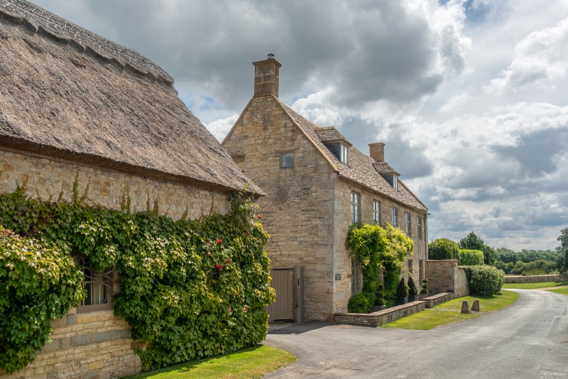
TREDINGTON ARMSCOTE
SP2444
8/212 Ladle Farmhouse and attached
wall
GV II
Farmhouse. Mid C18. Squared, coursed limestone with ashlar quoins and coped
gables. Stone slate roof with ashlar end stacks. 2 storeys plus attic; 4-window
range. L-shaped plan. To centre a 4-panelled door with overlight and flat stone
arch. C19 hood. To ground and first floors a range of four C19 horned sashes
with flat stone arches. Further blocked window with flat stone arch above door.
To left and right of roof a C19 hipped dormer. Sundial on right gable end.
Extending to rear a long C18 stone range with coped gable and stone slate roof
with rendered ridge stacks. 2 storeys; 4-window range. To centre a 6-panelled
door with large flat hood supported on pillars. C18 two- and three-light
casements with leaded lights with some C19 and C20 casements. Small stone
lean-to to left. Attached to right of farmhouse, extending approximately 40
metres, a wall of squared, coursed limestone with stone coping, approximately 2
metres high.
Listing NGR: SP2437044625
External links are from the relevant listing authority and, where applicable, Wikidata. Wikidata IDs may be related buildings as well as this specific building. If you want to add or update a link, you will need to do so by editing the Wikidata entry.


Other nearby listed buildings