Approximate Location Map
Large Map »
Latitude: 52.1253 / 52°7'30"N
Longitude: -1.4003 / 1°24'0"W
OS Eastings: 441154
OS Northings: 247609
OS Grid: SP411476
Mapcode National: GBR 7RZ.LSY
Mapcode Global: VHBYC.PV34
Plus Code: 9C4W4HGX+4V
Entry Name: The Plough Public House
Listing Date: 8 April 1987
Grade: II
Source: Historic England
Source ID: 1024154
English Heritage Legacy ID: 306294
Also known as: Plough Inn
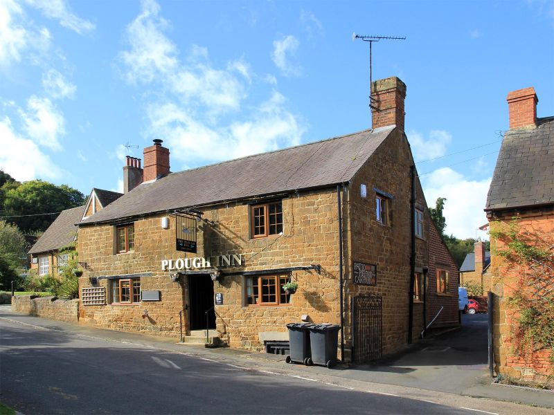
The Plough Inn, Banbury
ID on this website: 101024154
Location: Warmington, Stratford-on-Avon, Warwickshire, OX17
County: Warwickshire
District: Stratford-on-Avon
Civil Parish: Warmington
Built-Up Area: Warmington
Traditional County: Warwickshire
Lieutenancy Area (Ceremonial County): Warwickshire
Church of England Parish: Warmington St Michael
Church of England Diocese: Coventry
Tagged with: Pub
WARMINGTON CHURCH HILL
SP4047 (North side)
9/183 The Plough Public House
GV II
Public house. Possibly C17 origins, raised and altered late C18/early C19. Coursed squared ironstone rubble. Slate roof; brick end stacks. 2-unit plan. 2 storeys; 2-window range. Central recessed part-glazed C20 door. Old 3-light casements with glazing bars. First floor has late C19 casements with horizontal glazing bars. Interior: stepped stop-chamfered ceiling beam. Open fireplace. Included for group value.
Listing NGR: SP4115447609
External links are from the relevant listing authority and, where applicable, Wikidata. Wikidata IDs may be related buildings as well as this specific building. If you want to add or update a link, you will need to do so by editing the Wikidata entry.


Other nearby listed buildings
