Approximate Location Map
Large Map »
Latitude: 52.0506 / 52°3'2"N
Longitude: -1.5422 / 1°32'31"W
OS Eastings: 431489
OS Northings: 239235
OS Grid: SP314392
Mapcode National: GBR 6RF.DXL
Mapcode Global: VHBYP.7Q1C
Plus Code: 9C4W3F25+64
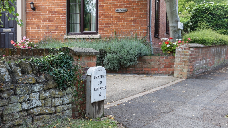
Entry Name: Milestone Approximately 300 Metres South of Church
Listing Date: 30 June 1986
Grade: II
Source: Historic England
Source ID: 1024385
English Heritage Legacy ID: 305809
ID on this website: 101024385
Location: Lower Brailes, Stratford-on-Avon, Warwickshire, OX15
County: Warwickshire
District: Stratford-on-Avon
Civil Parish: Brailes
Built-Up Area: Lower Brailes
Traditional County: Warwickshire
Lieutenancy Area (Ceremonial County): Warwickshire
Church of England Parish: Brailes St George
Church of England Diocese: Coventry
Tagged with: Milestone
BRAILES HIGH STREET
SP3139 (South side)
Lower Brailes
15/46 Milestone approx. 300m. S of
Church
GV II
Milestone. C19. Cast-iron plaque on renewed wooden post. Inscription:
Brailes/Banbury/10/Shipston/4.
Listing NGR: SP3148839236
External links are from the relevant listing authority and, where applicable, Wikidata. Wikidata IDs may be related buildings as well as this specific building. If you want to add or update a link, you will need to do so by editing the Wikidata entry.


Other nearby listed buildings
