Approximate Location Map
Large Map »
Latitude: 54.9827 / 54°58'57"N
Longitude: -1.607 / 1°36'25"W
OS Eastings: 425251
OS Northings: 565420
OS Grid: NZ252654
Mapcode National: GBR SQ6.SS
Mapcode Global: WHC3R.901Z
Plus Code: 9C6WX9MV+36
Entry Name: Piers from Hospital of the Virgin Mary of Royal Grammar School
Listing Date: 30 March 1987
Grade: II
Source: Historic England
Source ID: 1024894
English Heritage Legacy ID: 304545
ID on this website: 101024894
Location: Brandling Village, Newcastle upon Tyne, Tyne and Wear, NE2
County: Newcastle upon Tyne
Electoral Ward/Division: South Jesmond
Parish: Non Civil Parish
Built-Up Area: Newcastle upon Tyne
Traditional County: Northumberland
Lieutenancy Area (Ceremonial County): Tyne and Wear
Church of England Parish: Jesmond Clayton Memorial Church
Church of England Diocese: Newcastle
Tagged with: Gatepost
NZ 26 NE NEWCASTLE UPON TYNE ESKDALE TERRACE
(west side)
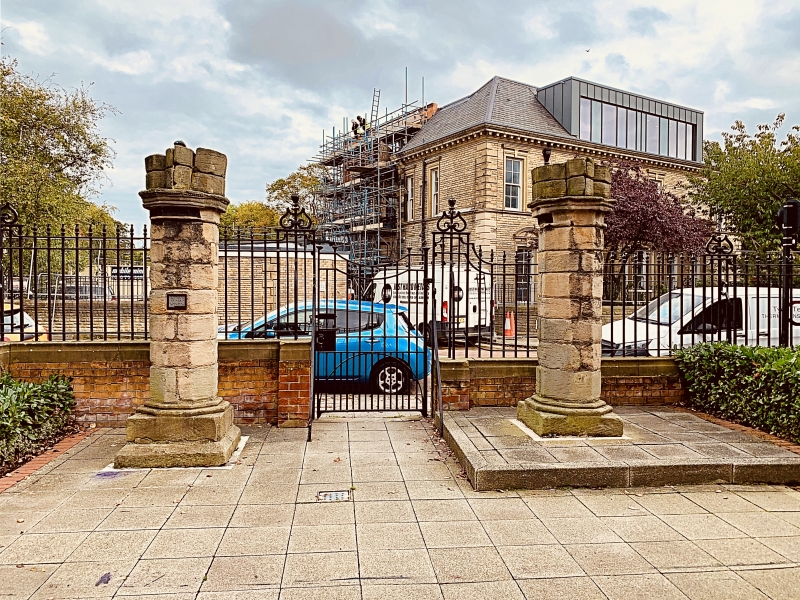
9/233 Piers from Hospital of
the Virgin Mary at
Royal Grammar School
G.V. II
2 piers, originally from Virgin Mary Hospital in Westgate Road and resited behind
gate piers at school entrance. C13. Sandstone. Octagonal piers, each on square
plinth and moulded base; nail-head band on moulded capitals; each has 2 courses of
springing of chamfered arches and side arches. In the eighteenth century the
Grammar School occupied the buildings of the former hospital; they were demolished
when Neville Street was laid out c.1844.
Listing NGR: NZ2525165420
External links are from the relevant listing authority and, where applicable, Wikidata. Wikidata IDs may be related buildings as well as this specific building. If you want to add or update a link, you will need to do so by editing the Wikidata entry.


Other nearby listed buildings
