Latitude: 54.979 / 54°58'44"N
Longitude: -1.6321 / 1°37'55"W
OS Eastings: 423645
OS Northings: 564992
OS Grid: NZ236649
Mapcode National: GBR SLL.79
Mapcode Global: WHC3Q.W3ZW
Plus Code: 9C6WX9H9+H5
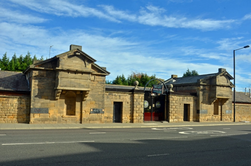
Entry Name: Former North Guard House and Attached Wall to North West, Fenham Barracks
Listing Date: 17 December 1971
Last Amended: 4 February 1999
Grade: II
Source: Historic England
Source ID: 1024950
English Heritage Legacy ID: 304381
ID on this website: 101024950
Location: Arthur's Hill, Newcastle upon Tyne, Tyne and Wear, NE4
County: Newcastle upon Tyne
Electoral Ward/Division: Wingrove
Parish: Non Civil Parish
Built-Up Area: Newcastle upon Tyne
Traditional County: Northumberland
Lieutenancy Area (Ceremonial County): Tyne and Wear
Church of England Parish: Newcastle St Andrew
Church of England Diocese: Newcastle
Tagged with: Building
NEWCASTLE UPON TYNE
NZ 26 NW
BARRACK ROAD
(North East side)
1833/8/80
Former N guard house and attached wall to north-west, Fenham Barracks
17.12.71
GV II
Barrack guard house and office, later restaurant, disused at time of inspection. 1804-06, by James Wyatt, Surveyor General to the Ordnance Board, restaurant 1970-90. Brown sandstone ashlar guard house with ashlar gable stacks, rear brick block, with slate hipped and gabled roof. Single-depth plan with offices to the left. EXTERIOR: Single storey; windowless street front, 9-window rear office elevation. Guard house gable has a coped pediment with raised comer blocks, a central raised round-headed niche in a blind recess beneath an overhanging blind oriel on moulded stone brackets, rising to the top of the pediment, and containing 3 rifle slots beneath a blind lunette; 4 courses from the ground the quoins are replaced by wide cast-iron blocks. To the left a coped wall with flat-headed opening and rusticated pier to former barracks entrance; Brick block has flat-headed openings, boarded at time of survey (1994). INTERIOR: Not inspected. SUBSIDIARY FEATURES: Attached former barracks wall with flat coping, forming the front wall to the office, extends approximately 100m to the north-west. HISTORY: The Ordnance Board were responsible for Artillery barracks during the Napoleonic War. One of a pair of striking and unusual guard houses to Fenham Artillery Barracks, connected by a late C20 glazed archway to the gateway (not of special interest), and part of a group with the former sergeants' messes (qqv). (Mackenzie: History of Newcastle: 1827-: 710; Archaeologia Aeliana, 5th series: Breihan J: Army Barracks in the NE in the Era of the French Revolution: 1990-: 171).
Listing NGR: NZ2364564992
External links are from the relevant listing authority and, where applicable, Wikidata. Wikidata IDs may be related buildings as well as this specific building. If you want to add or update a link, you will need to do so by editing the Wikidata entry.


Other nearby listed buildings