Approximate Location Map
Large Map »
Latitude: 54.9486 / 54°56'55"N
Longitude: -1.3697 / 1°22'10"W
OS Eastings: 440468
OS Northings: 561736
OS Grid: NZ404617
Mapcode National: GBR LCW6.8V
Mapcode Global: WHD4Z.XWX5
Plus Code: 9C6WWJXJ+F4
Entry Name: Wall to West of No 48 (Whitehouse Farm)
Listing Date: 26 February 1985
Grade: II
Source: Historic England
Source ID: 1025224
English Heritage Legacy ID: 303705
ID on this website: 101025224
Location: Whitburn, South Tyneside, Tyne and Wear, SR6
County: South Tyneside
Electoral Ward/Division: Whitburn and Marsden
Parish: Non Civil Parish
Built-Up Area: Whitburn
Traditional County: Durham
Lieutenancy Area (Ceremonial County): Tyne and Wear
Church of England Parish: Whitburn
Church of England Diocese: Durham
Tagged with: Wall
NZ 46SW BOLDON FRONT STREET (south side)
Whitburn
4/46 Wall to west of No 48
(Whitehouse Farm)
-
GV II
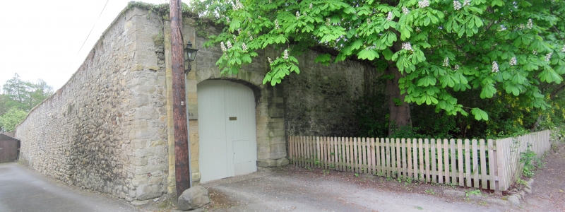
High wall, late C18/early C19, forming the west side of the entrance to the
yard of Whitehouse Farm and extending 23 metres along Front Street. Limestone
rubble, with sandstone piers and elliptical brick arch to carriage entrance
at its eastern end.
Listing NGR: NZ4046861736
External links are from the relevant listing authority and, where applicable, Wikidata. Wikidata IDs may be related buildings as well as this specific building. If you want to add or update a link, you will need to do so by editing the Wikidata entry.


Other nearby listed buildings
