Approximate Location Map
Large Map »
Latitude: 54.9475 / 54°56'51"N
Longitude: -1.368 / 1°22'4"W
OS Eastings: 440578
OS Northings: 561613
OS Grid: NZ405616
Mapcode National: GBR LCW7.M7
Mapcode Global: WHD4Z.YXQ1
Plus Code: 9C6WWJXJ+2Q
Entry Name: East-West Wall 35 Metres South of Red Cottage and Linking Wall to House
Listing Date: 26 February 1985
Grade: II
Source: Historic England
Source ID: 1025246
English Heritage Legacy ID: 303665
ID on this website: 101025246
Location: Whitburn, South Tyneside, Tyne and Wear, SR6
County: South Tyneside
Electoral Ward/Division: Whitburn and Marsden
Parish: Non Civil Parish
Built-Up Area: Whitburn
Traditional County: Durham
Lieutenancy Area (Ceremonial County): Tyne and Wear
Church of England Parish: Whitburn
Church of England Diocese: Durham
Tagged with: Wall
NZ 46 SW BOLDON CHURCH LANE (west side)
Whitburn
4/6
East-west wall 35 metres
south of Red Cottage and
linking wall to house
GV II
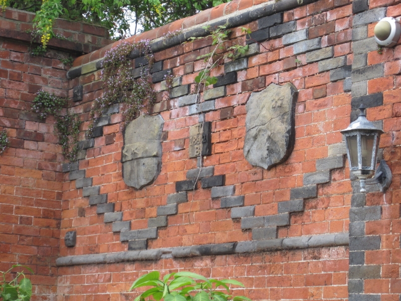
Wall, dated 1842, for Thomas Barnes. Red and grey brick with sandstone embellish-
ments. 8 rectangular piers with grey brick corners and string courses, plinth
coping on piers and along wall, and string at wall coping and at tops of piers;
moulded coping of bright red brick. Grey brick diapers enclose coat of arms,
panels 'T1842B' and starfish all in sandstone. Plainer wall of red and grey brick
which connects Red Cottage with the decorated wall is included for group value
with those structures.
Listing NGR: NZ4057861613
External links are from the relevant listing authority and, where applicable, Wikidata. Wikidata IDs may be related buildings as well as this specific building. If you want to add or update a link, you will need to do so by editing the Wikidata entry.


Other nearby listed buildings
