Latitude: 52.5843 / 52°35'3"N
Longitude: -2.194 / 2°11'38"W
OS Eastings: 386955
OS Northings: 298511
OS Grid: SO869985
Mapcode National: GBR 19B.XTL
Mapcode Global: WHBFY.89HP
Plus Code: 9C4VHRM4+PC
Entry Name: Stable Buildings and Attached Walls to North of Wightwick Manor
Listing Date: 3 February 1977
Last Amended: 31 March 1992
Grade: II
Source: Historic England
Source ID: 1025262
English Heritage Legacy ID: 378655
ID on this website: 101025262
Location: Wightwick, Wolverhampton, West Midlands, WV6
County: City of Wolverhampton
Electoral Ward/Division: Tettenhall Wightwick
Parish: Non Civil Parish
Built-Up Area: Wolverhampton
Traditional County: Staffordshire
Lieutenancy Area (Ceremonial County): West Midlands
Church of England Parish: Tettenhall Wood Christ Church
Church of England Diocese: Lichfield
Tagged with: Stable
WOLVERHAMPTON
SO89NE WIGHTWICK BANK 895-1/4/184 (West side) 03/02/77 Stable buildings and attached walls to N of Wightwick Manor (Formerly Listed as: WIGHTWICK BANK, Wightwick Stables of Wightwick Manor)
GV II
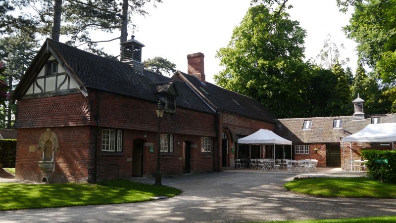
Stable buildings and walls to west and south. Probably C18, restored late C19 for Theodore Mander. Brick with tile hanging and tile roofs. L-plan. Single storey. North wing has stables and loose boxes; segmental-headed entrances and small-paned windows; south wing has tile-hung 1st floor with similar entrances and windows and gabled pitching hole to left of garage doors; louvre; south end has inset drinking fountain with round-headed niche with rich surround and mask, removed from Market Hall, (demolished, 1961). INTERIOR: some late C19 stable fittings and tack room. Wall extending approx 20m to east joins this item with Garage and garden seat (q.v.): mid to late C19, brick with half round blue brick coping, paired gates with plain brick piers. Wall extending approx 20m to south, to gatepier to main entrance: late C19, brick with red brick coping, paired gates to north end with plain brick piers.
Listing NGR: SO8695598511
External links are from the relevant listing authority and, where applicable, Wikidata. Wikidata IDs may be related buildings as well as this specific building. If you want to add or update a link, you will need to do so by editing the Wikidata entry.


Other nearby listed buildings