Approximate Location Map
Large Map »
Latitude: 55.0093 / 55°0'33"N
Longitude: -1.4449 / 1°26'41"W
OS Eastings: 435601
OS Northings: 568441
OS Grid: NZ356684
Mapcode National: GBR LBBJ.Z3
Mapcode Global: WHD4R.SC55
Plus Code: 9C7W2H54+P3
Entry Name: Baptist Church
Listing Date: 19 February 1986
Last Amended: 30 September 2022
Grade: II
Source: Historic England
Source ID: 1025378
English Heritage Legacy ID: 303329
ID on this website: 101025378
Location: North Shields, North Tyneside, Tyne and Wear, NE30
County: North Tyneside
Electoral Ward/Division: Tynemouth
Parish: Non Civil Parish
Built-Up Area: Tynemouth
Traditional County: Northumberland
Lieutenancy Area (Ceremonial County): Tyne and Wear
Church of England Parish: North Shields Christ Church
Church of England Diocese: Newcastle
Tagged with: Protestant church building
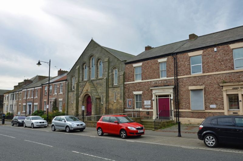
Baptist Church, 1845-1846, by John Dobson of North Shields.
Baptist Church, 1845 to 1846, by John Dobson of North Shields. Neo-Norman style.
MATERIALS: coursed sandstone ashlar. Pitched slate roof. Cast-iron gallery columns supporting a wooden king-post truss roof.
PLAN: an east-west aligned church facing Howard street. Rectangular on plan.
EXTERIOR: the gable-ended, three-bay main (east) elevation has a symmetrical two-storey street frontage in the neo-Norman style, with a raised plinth, string course, capped buttresses and roll-moulded gable coping and rectangular kneelers. The tall inner buttresses accentuate a wide central bay, which has a gabled porch, and a bay either side. The main doorway set within the gabled porch has a round-headed roll-moulded arch supported by a single nook shaft either side. The chamfered inner arch has the incised and painted inscription: BAPTIST + CHAPEL / MDCCCXLVI. The doorway retains the cast-iron base of a gas lamp above and shaped iron railings and steps which rise up to a two-leaf wooden door decorated with foliated strapwork hinges. Either side of the porch is a narrow round-headed single pane window and above the string course forms the lintel to a central three-light window, with similar roll-moulded arches and nook shafts. The outer bays have again a similar, but simplified, upper window and a narrow round-headed single pane window below. Rear not inspected, information provided from photographic and other sources. The north and south blind returns are of sandstone rubble, with terraced houses abutting both sides. The rear (west) elevation is of sandstone rubble with ashlar quoins. It is lit by four round-headed windows in quoined openings, the central pair taller than the outer two.
INTERIOR: the small entrance vestibule has a narrow north and south stair leading up to the gallery and a central round-headed west window, looking into the church, with an aisle doorway either side. The church layout follows the usual Nonconformist plan-type, with a directional focus on the west end where the pulpit and baptistery were situated. It has a late-C20 communion platform and reading desk over the former mid-C19 baptistery and a gallery on the north, south and east sides of the church. The gallery front is decorated with panels, defined by raised mouldings, with chevron carving under the handrail, and a clock in the centre of the east gallery front. It is supported on cast-iron columns with functioned ribbed capitals on the ground floor and more elaborate Ionic capital on the first floor. The first-floor columns support, with bracing, two arcade plates running from the front to the back of the building, which in turn carry king-post trusses over the church nave. The principal rafters of the side aisles have braces which rise from decorative wooden corbels to provide additional strength. The plaster ceiling is early-C20, with a decorative ventilation roundel. A former changing room, to the north of the pulpit, is now an office. Three blocked windows at the south end of the west wall indicate the location of another forming changing room.
This list entry was subject to a Minor Amendment on 3 October 2022 to correct a typo in the Reason for Designation
In 1796 John Wright (1730-1806), lawyer and property developer, purchased 50 acres of land between Norfolk Street and Newcastle Street from Frederick Howard, fifth Earl of Carlisle, for the development of the New Town of North Shields. He developed several elegant streets and it is suggested Northumberland Place, Northumberland Square and Howard Street were originally part of a high-status street scheme that Wright and his sons devised and implemented before selling freehold buildings plots to individuals. A substantial mansion, Wakefield House, was built by George Wakefield (around 1764-1806, banker) as the northern vista to the intended grand principal way from Howard Street to Northumberland Square, but due to financial difficulties and the death of George Wakefield, it was demolished in the 1800s. Northumberland Place and the south foot of Howard Street, below Saville Street, were developed first with housing and public buildings, with the earliest documentary evidence for Northumberland Place an 1800 release for premises. Between 1810 and 1816 Northumberland Square began development as a residential garden square when houses were built on the site of Wakefield House, re-using its materials and stylistically matching those already built on Northumberland Place. Further housing, public buildings and churches were built on Howard Street and Northumberland Square through the mid- to late C19.
The Baptist Church, built between 1845 and 1846, was the third site chosen by the Baptist community church for Divine Worship. In 1845 land was purchased on Howard Street at a cost of £147 and the sum of £1,200 was raised by subscriptions from the congregation for the completion of the church. John Dobson (1787-1865), one of the most eminent architects to be born and work in the north-east of England, was commissioned to design the building. Dobson set up his practice in North Shields in 1810 and by 1815 was involved in planning several residential developments in Newcastle. He was known for his work with Richard Grainger (1797-1861) and designed a wide range of buildings, including churches, public buildings, villas and major country houses. Dobson's designs usually cost between £3,000 and £7,000 and this building reflects the congregation’s desire to employ a professional architect, despite financial constraints, at a time when architects were rare in the North. It lies near to three of Dobson’s other designs: the Baptist Church, the former New United Presbyterian Church (St Columba’s church) and the former public building on the corner of Howard and Saville Street.
The building opened for Divine Worship on 16 April 1846 and shortly after the church's opening it welcomed, on 8 September, through connections with the prominent anti-slavery and Quaker Spence and Richardson families, the slavery abolitionist, author and diplomatist Frederick Douglass (about 1818-1895) to speak on the system of American slavery and evangelical alliance. Douglass spoke to thousands in public halls, private homes, chapels and churches during a 19-month tour of Ireland, England and Scotland, speaking on the abolitionist's cause, women’s rights, temperance, land reform, education and capital punishment. Following the completion of the tour, he returned to the US free, following the purchase of his freedom by Ellen and Anna Richardson.
As constructed the church had a mid-C19 underfloor baptistery covered by a late-C19 communion platform and a pulpit, the latter a grand preaching rostrum in 1866. A gallery, running along the north, south and east sides of the church, was supported on wooden pillars at ground and first-floor level, with wooden box pews across the main church floor. In 1882 the gallery’s wooden columns were replaced by cast iron and in 1895 the box pews were replaced by Swan & Hunter of Wallsend pine pews. A small vestry, used as a changing room, was positioned at the back of the church and later replaced by a lecture hall. Heating was first introduced into the building in 1866 with the insertion of a stove and a brick chimney at the apex of the west gable (now removed) and replaced through several iterations. Lighting was similarly upgraded, from gas jets to gasoliers in 1877, to ‘Clapton Lights’ in 1899 and electric lighting in the early C20. The Vestries and meeting rooms are now situated in the adjacent terraced houses to the north of the church (58 Howard Street), with doorways inserted between the house and church on both floors. In 1998 the church floor was re-organised, which included the removal of the raised platform and pews and relocation of the baptistery.
Baptist Church, North Shields, 1845-1846, by John Dobson of North Shields, is listed at Grade II for the following principal reasons:
Architectural interest:
* for its understated elegant neo-Norman styling, which contributes to the surrounding streetscape and reflects both the aspirations and financial constraints of the congregation;
* as a good example of the work of John Dobson, one of the most eminent C19 architects in the north-east of England;
* the interior retains its character and identity as a mid-C19 Baptist church despite later alteration, including the high-quality two-storey cast-iron and wood gallery.
Historic interest:
* as one of the venues that welcomed Frederick Douglass during his tour of England, Scotland and Wales in 1846, speaking on the system of slavery.
Group value:
* it has strong group value with a range of listed buildings within the area, particularly buildings designed by John Dobson, in highlighting the development of Northumberland Square and Howard Street in the new town of North Shields.
External links are from the relevant listing authority and, where applicable, Wikidata. Wikidata IDs may be related buildings as well as this specific building. If you want to add or update a link, you will need to do so by editing the Wikidata entry.


Other nearby listed buildings
