Approximate Location Map
Large Map »
Latitude: 50.7913 / 50°47'28"N
Longitude: -0.6522 / 0°39'7"W
OS Eastings: 495098
OS Northings: 99943
OS Grid: SZ950999
Mapcode National: GBR FJV.9Y5
Mapcode Global: FRA 97J0.1RJ
Plus Code: 9C2XQ8RX+G4
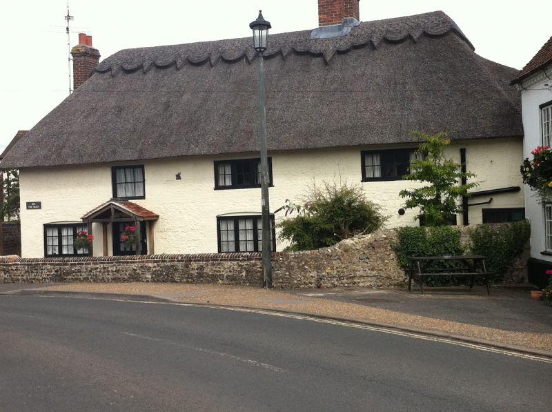
Entry Name: The Barn
Listing Date: 7 November 1975
Grade: II
Source: Historic England
Source ID: 1027783
English Heritage Legacy ID: 297580
ID on this website: 101027783
Location: Felpham, Arun, West Sussex, PO22
County: West Sussex
District: Arun
Civil Parish: Felpham
Built-Up Area: Bognor Regis
Traditional County: Sussex
Lieutenancy Area (Ceremonial County): West Sussex
Church of England Parish: Felpham St Mary
Church of England Diocese: Chichester
Tagged with: Building Thatched barn
FELPHAM ROAD
1.
5401
(East Side)
FELPHAM
------------
No 1O4 (The Barn)
SZ 9599 18/43
II
2.
Next to The George Inn and at right-angles to it, on bend in road. Probably C17.
2 storeys. 3 windows. Flints and rubble now painted. Thatched roof. Modern
casement windows.
Listing NGR: SZ9509899943
External links are from the relevant listing authority and, where applicable, Wikidata. Wikidata IDs may be related buildings as well as this specific building. If you want to add or update a link, you will need to do so by editing the Wikidata entry.


Other nearby listed buildings
