Latitude: 50.8331 / 50°49'59"N
Longitude: -0.2766 / 0°16'35"W
OS Eastings: 521458
OS Northings: 105149
OS Grid: TQ214051
Mapcode National: GBR HMF.NX0
Mapcode Global: FRA B69W.XQ2
Plus Code: 9C2XRPMF+79
Entry Name: Shoreham House
Listing Date: 29 September 1972
Grade: II
Source: Historic England
Source ID: 1027868
English Heritage Legacy ID: 297298
ID on this website: 101027868
Location: Shoreham-by-Sea, Adur, West Sussex, BN43
County: West Sussex
District: Adur
Electoral Ward/Division: St Mary's
Parish: Non Civil Parish
Built-Up Area: Shoreham-by-Sea
Traditional County: Sussex
Lieutenancy Area (Ceremonial County): West Sussex
Church of England Parish: New Shoreham St Mary de Haura
Church of England Diocese: Chichester
Tagged with: House
This list entry was subject to a Minor Amendment on 3 March 2026 to update the Name, Address and Details and reformat the text to current standards
TQ 2105 SW
6/7
SHOREHAM-BY-SEA JOHN STREET (west side)
No 21 (Shoreham House)
(Formerly listed as No 17 (Shoreham House))
GV
II
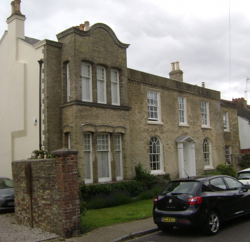
House. Circa 1800, extended to left c.1880. Gault brick with red brick cornice to rendered parapet hiding roof. End stacks. Two storeys.
To right: three bays, 'regular glazing bar sashes with cills, round-arched on ground floor. Central panelled door in round-arched surround with radiating fanlight, flanked by wooden piers supporting open pediment hood. To left: square two-storey bay with Dutch-type gable.
Segment-headed windows with three sashes to front and one in each side; glazing bars only in upper blades
The north-end bay has been incorporated into the adjacent 23 John Street (listed Grade II).
Listing NGR: TQ2145805149
External links are from the relevant listing authority and, where applicable, Wikidata. Wikidata IDs may be related buildings as well as this specific building. If you want to add or update a link, you will need to do so by editing the Wikidata entry.


Other nearby listed buildings