Approximate Location Map
Large Map »
Latitude: 51.0457 / 51°2'44"N
Longitude: 0.2198 / 0°13'11"E
OS Eastings: 555702
OS Northings: 129720
OS Grid: TQ557297
Mapcode National: GBR MQW.8F1
Mapcode Global: FRA C6BC.5FV
Plus Code: 9F3226W9+7W
Entry Name: The King's Arms Public House
Listing Date: 31 December 1982
Grade: II
Source: Historic England
Source ID: 1028144
English Heritage Legacy ID: 296653
ID on this website: 101028144
Location: Rotherfield, Wealden, East Sussex, TN6
County: East Sussex
District: Wealden
Civil Parish: Rotherfield
Built-Up Area: Rotherfield
Traditional County: Sussex
Lieutenancy Area (Ceremonial County): East Sussex
Church of England Parish: Rotherfield St Denys
Church of England Diocese: Chichester
Tagged with: Pub
1.
5208
TQ 5529
38/224
ROTHERFIELD
SOUTH STREET
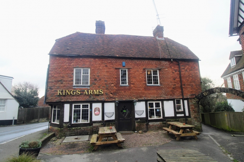
The King's Arms Public House
II
2.
Restored C17 timber-framed building with plaster infilling, the first floor
tile-hung. Half-hipped tiled roof. Casement windows. Two storeys. Three
windows. Later additions behind.
Listing NGR: TQ5570229720
External links are from the relevant listing authority and, where applicable, Wikidata. Wikidata IDs may be related buildings as well as this specific building. If you want to add or update a link, you will need to do so by editing the Wikidata entry.


Other nearby listed buildings
