Latitude: 51.0457 / 51°2'44"N
Longitude: 0.2194 / 0°13'9"E
OS Eastings: 555676
OS Northings: 129719
OS Grid: TQ556297
Mapcode National: GBR MQW.89R
Mapcode Global: FRA C6BC.59G
Plus Code: 9F3226W9+7Q
Entry Name: 1, High Street
Listing Date: 18 April 1973
Grade: II
Source: Historic England
Source ID: 1028174
English Heritage Legacy ID: 296629
ID on this website: 101028174
Location: Rotherfield, Wealden, East Sussex, TN6
County: East Sussex
District: Wealden
Civil Parish: Rotherfield
Built-Up Area: Rotherfield
Traditional County: Sussex
Lieutenancy Area (Ceremonial County): East Sussex
Church of England Parish: Rotherfield St Denys
Church of England Diocese: Chichester
Tagged with: Building
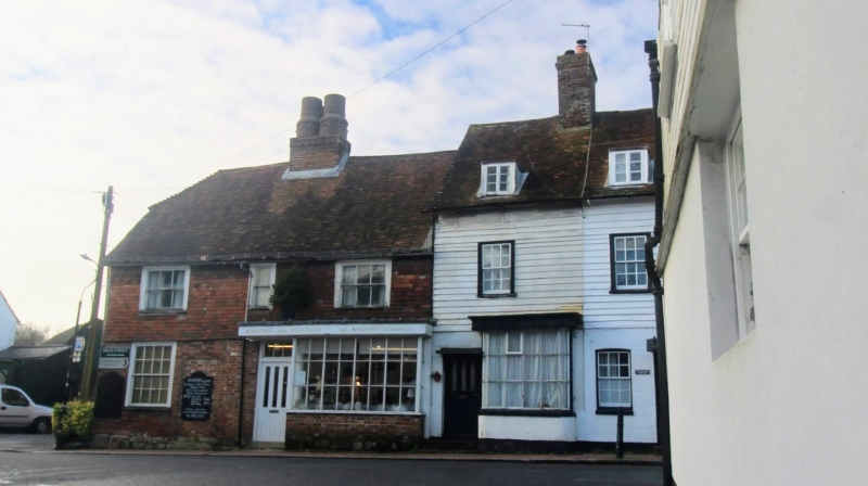
ROTHERFIELD HIGH STREET
1.
5208
(west side)
No 1
TQ 5529 38/216 18.4.73
II GV
2.
C16 to C17. Two storeys. Three windows. Ground floor red brick, above tile-
hung. Tiled roof. Central chimney stack with four round shafts. Sash windows with
glazing bars.
Listing NGR: TQ5567629719
External links are from the relevant listing authority and, where applicable, Wikidata. Wikidata IDs may be related buildings as well as this specific building. If you want to add or update a link, you will need to do so by editing the Wikidata entry.


Other nearby listed buildings