Latitude: 51.2956 / 51°17'44"N
Longitude: -0.327 / 0°19'37"W
OS Eastings: 516740
OS Northings: 156491
OS Grid: TQ167564
Mapcode National: GBR 7J.66L
Mapcode Global: VHGRV.8PZN
Plus Code: 9C3X7MWF+65
Entry Name: Duke's Head Public House
Listing Date: 7 September 1951
Grade: II
Source: Historic England
Source ID: 1028626
English Heritage Legacy ID: 290545
ID on this website: 101028626
Location: Leatherhead, Mole Valley, Surrey, KT22
County: Surrey
District: Mole Valley
Electoral Ward/Division: Leatherhead North
Parish: Non Civil Parish
Built-Up Area: Leatherhead
Traditional County: Surrey
Lieutenancy Area (Ceremonial County): Surrey
Church of England Parish: Leatherhead
Church of England Diocese: Guildford
Tagged with: Pub
This list entry was subject to a Minor Amendment on 25 February 2025 to amend the name and address and reformat the text to current standards.
TQ 1656 SE
12/148
LEATHERHEAD
HIGH STREET (north side)
No 57, Duke's Head Public House
(Formerly listed as Duke's Head Public House, HIGH STREET)
7.9.51
GV
II
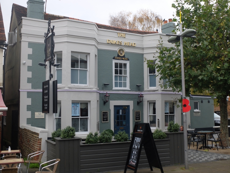
Inn, now public house. C17 and C18, remodelled in C19; altered in C20. Timber frame with brick cladding and stucco facade; red tile roof. Single-depth front range with coupled rear wings of unequal length. Two storeys and three bays; the almost symmetrical C19 facade has painted quoins and a high banded parapet; the principal doorway is offset slightly to the right, has a shouldered surround of plain render and is protected by a flat canopy carried across at first floor between flanking full-height canted bays; at first floor above the canopy is a twelve-pane sashed window with an exposed box and plaster cresting lettered "DUKES HEAD" under a roundel showing the duke's head; and the flanking bays have four-pane sashes except at ground floor to the right where the window has been replaced by a doorway. There is an extruded chimney stack at the right-hand gable and a single chimney at the front left corner.
At the right-hand end is a single-storey flat-roofed modern addition (not of special interest), and the rear slope of the roof carries down to the lower level of the rear wing, which has various openings on this side, and on the other side is mostly covered by a modern addition but has some exposed timber framing above this.
Interior: altered at ground floor and partition walls removed, but some remains of timber framing are visible; otherwise, not inspected.
Listing NGR: TQ1674056491
External links are from the relevant listing authority and, where applicable, Wikidata. Wikidata IDs may be related buildings as well as this specific building. If you want to add or update a link, you will need to do so by editing the Wikidata entry.


Other nearby listed buildings