Approximate Location Map
Large Map »
Latitude: 52.889 / 52°53'20"N
Longitude: -2.4615 / 2°27'41"W
OS Eastings: 369043
OS Northings: 332488
OS Grid: SJ690324
Mapcode National: GBR 7W.Q2KS
Mapcode Global: WH9C4.5N33
Plus Code: 9C4VVGQQ+H9
Entry Name: Shropshire Union Canal Bridge Number 60
Listing Date: 14 May 1985
Grade: II
Source: Historic England
Source ID: 1029862
English Heritage Legacy ID: 362643
ID on this website: 101029862
Location: Newcastle-under-Lyme, Staffordshire, TF9
County: Staffordshire
District: Newcastle-under-Lyme
Town: Newcastle-under-Lyme
Civil Parish: Loggerheads
Traditional County: Staffordshire
Lieutenancy Area (Ceremonial County): Staffordshire
Church of England Parish: Market Drayton St Mary
Church of England Diocese: Lichfield
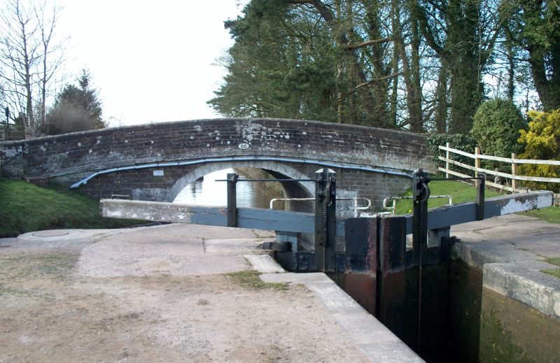
SJ 63 SE LOGGERHEADS C.P SHROPSHIRE UNION CANAL,
Tyrley Wharf
11/161 Bridge No.60
GV II
Canal bridge. C.1830. Thomas Telford and Alexander Easton, engineers.
Coursed sandstone with ashlar dressings. Wide elliptical hump-backed
arch with voussoirs; coped parapet and string course. Cast iron posts
on towpath side with grooves for holding ropes, formerly used on narrow
boats. This stretch of canal formerly formed part of the Birmingham
and Liverpool Junction Canal (Act passed 1826, opened 1835), which was
absorbed by the Ellesmere and Chester Canal in 1845 and eventually
became part of the Shropshire Union in 1846. The bridge, with its
painted voussoirs and string course, forms a picturesque group with
the first (southernmost) of Tyrley Locks (not included) and the buildings
on Tyrley Wharf (q.v.). V.C.H. II, (1967), p.295; Charles Hadfield,
The Canals of the West Midlands, (1966), Pp.183-9.
Listing NGR: SJ6904332487
External links are from the relevant listing authority and, where applicable, Wikidata. Wikidata IDs may be related buildings as well as this specific building. If you want to add or update a link, you will need to do so by editing the Wikidata entry.


Other nearby listed buildings
