Approximate Location Map
Large Map »
Latitude: 51.6932 / 51°41'35"N
Longitude: -1.6939 / 1°41'37"W
OS Eastings: 421257
OS Northings: 199431
OS Grid: SU212994
Mapcode National: GBR 4ST.YBF
Mapcode Global: VHC0B.LPDT
Plus Code: 9C3WM8V4+7F
Entry Name: Riverside Flats
Listing Date: 18 February 1998
Grade: II
Source: Historic England
Source ID: 1031607
English Heritage Legacy ID: 469077
ID on this website: 101031607
Location: Lechlade-on-Thames, Cotswold, Gloucestershire, GL7
County: Gloucestershire
District: Cotswold
Civil Parish: Lechlade
Built-Up Area: Lechlade-on-Thames
Traditional County: Gloucestershire
Lieutenancy Area (Ceremonial County): Gloucestershire
Church of England Parish: Lechlade St Lawrence
Church of England Diocese: Gloucester
Tagged with: Building
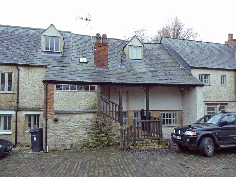
SU2199 LECHLADE PARKEND WHARF
500/10/10005 Riverside Flats
II
Warehouse, now dwelling and store. Circa early-mid C17. Timber-frame and stone. Gable-ended roof clad in concrete tiles and corrugated asbestos sheets. Later brick lateral stacks at front and rear . PLAN: 4-bay warehouse open to the roof originally, south front [and possibly the rear] open up to mid-rail level. In C18 a floor was inserted, the rear wall was under built in stone and external stone stairs were built at the back. In the C19 an outshut was built on the front. In C20 roof of outshut was lowered and building converted into flats. A later timber-framed wing at the west end was also demolished in C20. The five eastern bays, added probably soon after the original 4 bays, in the C17, were partly destroyed after a fire in 1996 are not of special historic interest.
EXTERIOR: 2 storeys. 2:4 window south front. Ground floor projecting stone outshut with five openings and later flat roof. First floor 12-pane sashes on right and 6-panesash on left with large 3-light window between with glazing bars. Rear, north, external stone stairs at centre, the main roof carried down over and supported on timber posts to right with lateral stack and gabled dormer above; 3 windows on each floor to left. West gable end faced in stone rubble and concrete blocks. East gable end abutting later C17 extension, partly destroyed after a fire in 1996.
INTERIOR: Inserted floor and later partitions. 4-bay roof structure with jowled posts with braces to tie-beams, queen-struts and collars with clasped purlins; common-rafters and ridgepiece appear to have been replaced.
SOURCE: RCHME survey report, January 1998.
Listing NGR: SU2125799431
External links are from the relevant listing authority and, where applicable, Wikidata. Wikidata IDs may be related buildings as well as this specific building. If you want to add or update a link, you will need to do so by editing the Wikidata entry.


Other nearby listed buildings
