Approximate Location Map
Large Map »
Latitude: 51.3552 / 51°21'18"N
Longitude: -1.8995 / 1°53'58"W
OS Eastings: 407091
OS Northings: 161800
OS Grid: SU070618
Mapcode National: GBR 3W9.SPR
Mapcode Global: VHB4J.164F
Plus Code: 9C3W9442+35
Entry Name: Number 30 and Number 32, Carisbrook
Listing Date: 29 April 1987
Grade: II
Source: Historic England
Source ID: 1033780
English Heritage Legacy ID: 311433
ID on this website: 101033780
Location: All Cannings, Wiltshire, SN10
County: Wiltshire
Civil Parish: All Cannings
Built-Up Area: All Cannings
Traditional County: Wiltshire
Lieutenancy Area (Ceremonial County): Wiltshire
Church of England Parish: All Cannings All Saints
Church of England Diocese: Salisbury
Tagged with: Building Thatched cottage
SU 06 SE
7/13
ALL CANNINGS
THE STREET
(north east side)
No 30 and 32, Carisbrook
II
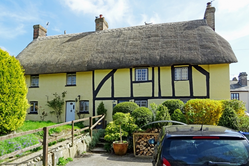
House and adjoining building, possibly barn, now 2 dwellings. C16
or C17. No 30 timber framed, with lower floor underbuilt in brick,
No 32 of brick with thatched roof to both. No 30, two storeys, two
bays, with entrance through 6-panelled door to left bay, and gable
stack to right. Storey high framing to upper floor with long
curved braces. Small paned metal casement windows. Gable and rear
wall rebuilt. No 32 said to have been a barn. Two storeys, two
bays, with boarded door on right and similar metal windows. Gable
of painted sarsen with datestone WS AS / 1647. Single storey rear
extension. Roof half hipped around gable stack.
Interior of No 30 has timber framed cross partition, now opened
up.
Listing NGR: SU0709161800
External links are from the relevant listing authority and, where applicable, Wikidata. Wikidata IDs may be related buildings as well as this specific building. If you want to add or update a link, you will need to do so by editing the Wikidata entry.


Other nearby listed buildings
