Approximate Location Map
Large Map »
Latitude: 52.7279 / 52°43'40"N
Longitude: -2.501 / 2°30'3"W
OS Eastings: 366260
OS Northings: 314589
OS Grid: SJ662145
Mapcode National: GBR BV.1BYQ
Mapcode Global: WH9CW.KP7L
Plus Code: 9C4VPFHX+5H
Entry Name: Canal Bridge North West of Covered Canal Dock Warehouse
Listing Date: 8 April 1983
Grade: II
Source: Historic England
Source ID: 1038627
English Heritage Legacy ID: 362120
ID on this website: 101038627
Location: Telford and Wrekin, Shropshire, TF6
County: Telford and Wrekin
Civil Parish: Eyton Upon The Weald Moors
Traditional County: Shropshire
Lieutenancy Area (Ceremonial County): Shropshire
Church of England Parish: Wellington All Saints
Church of England Diocese: Lichfield
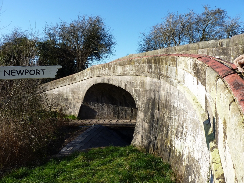
EYTON-UPON-THE-WEALD-MOORS WAPPENSHALL JUNCTION
1.
5362 Canal bridge north-west
of covered canal dock
warehouse
SJ 61 SE 28/255
II GV
2.
Early C19 canal bridge over the Newport branch of the Birmingham and Liverpool Junction
with the Shrewsbury Canal. Stone with round arch and ashlar parapets.
Listing NGR: SJ6626014589
External links are from the relevant listing authority and, where applicable, Wikidata. Wikidata IDs may be related buildings as well as this specific building. If you want to add or update a link, you will need to do so by editing the Wikidata entry.


Other nearby listed buildings
