Approximate Location Map
Large Map »
Latitude: 54.9013 / 54°54'4"N
Longitude: -3.0416 / 3°2'29"W
OS Eastings: 333301
OS Northings: 556784
OS Grid: NY333567
Mapcode National: GBR 7C6R.9T
Mapcode Global: WH801.72VD
Plus Code: 9C6RWX25+G8
Entry Name: Fairfield
Listing Date: 19 September 1984
Last Amended: 4 August 2022
Grade: II
Source: Historic England
Source ID: 1040026
English Heritage Legacy ID: 78255
ID on this website: 101040026
Location: Moorhouse, Cumberland, Cumbria, CA5
County: Cumbria
District: Carlisle
Civil Parish: Burgh by Sands
Traditional County: Cumberland
Lieutenancy Area (Ceremonial County): Cumbria
Church of England Parish: Burgh-by-Sands St Michael
Church of England Diocese: Carlisle
Tagged with: Building
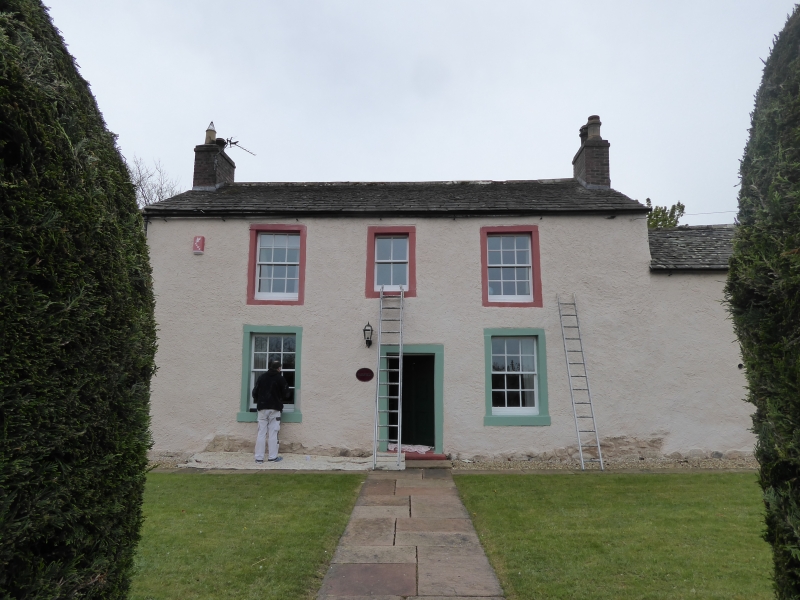
House, probably late C17, remodelled in the mid-C18; C20 and early-C21 alterations and extensions.
House, probably late C17, remodelled in the mid-C18; C20 and early-C21 alterations and extensions.
MATERIALS: clay walls, raised and extended in stone and brick, lime rendered and painted; graduated slate roofs with sandstone edging, brick chimney stacks.
PLAN: original cross-passage plan house, converted to a double-fronted central entry plan with rear stair hall addition.
EXTERIOR: the main six-bay (north) elevation is rendered and painted and has a partially visible stone boulder plinth and padstone. It comprises a central two-storey three-bay section, an eastern single storey two-bay section, and a western one-bay, single-storey section. The central section has a shallow, pitched roof of grey slate with a stone ridge and brick end stacks. All door and window openings have plain, square-section sandstone surrounds of C18 form; the main entrance has a six-panel door and mostly six-over-six unhorned sliding sashes except for a 2-pane sash window above the entrance. The eastern section has a pitched roof of graduated grey slate with two courses of stone edge slates. It has two windows in plain stone surrounds, one with a six-pane casement frame and one with a nine-pane frame; the latter window occupies the position of the former north entrance to the cross passage. The western section of the elevation is blind. The right and left returns are also blind, the latter irregular in profile reflecting its clay construction, and has a stone plinth. The rear elevation east end has an overhanging roof with a pair of roof dormers, a partially visible stone plinth and an entrance in a plain stone surround. To the left there is a lean-to extension with stone-slated roof. A full-height modern, flat-roofed extension obscures the next part of the rear elevation; within this extension, the original south entrance to the former cross passage has a datestone above recording the initials and date ‘J M 1730’. The gabled, stair cross wing has a ground floor and two first floor windows with six-over-six unhorned sash windows and stone sills. The former pigeon loft at the west end of the rear elevation has inserted doors and windows to both floors.
INTERIOR: the original cross-passage plan-form was modified by the mid-C18 plan-form, but both remain clearly legible. The eastern service end today incorporates the former cross passage, and its inserted first floor is supported by a pair of waney beams. The original cruck-framed roof structure is retained to this section; the lower parts of the trusses are partially visible to the ground floor and fully visible to the first floor (accessed via an inserted stair). They comprise a ridge beam, double purlins, and a pair of braced, full crucks, with blades tenoned and pegged into a yoke at the ridge, and a tie beam pegged to the blades. The lower purlin on south side has been modified to receive a pair of dormer windows. There is a mid-C18 triangular truss to the west gable. The modernised central and eastern end of the house has loftier dimensions, and a central entrance hall, flanked to either side by a reception room. Each room is entered through an original six-panel door: the eastern room has a mid-C18 moulded plaster ceiling and cornice and a possible C18 chimney piece; two encased ceiling beams are finely treated with plaster mouldings. The western room has a single substantial exposed chamfered, timber ceiling beam, and a possible C18 moulded chimney timber piece. The rear stair range is entered from the back of the hall through an arched opening, and retains its mid-C18 dog-leg staircase set parallel to the rear wall; this is open string, has stick balusters and a mahogany ramped and wreathed handrail. The first floor has a balustraded landing and mostly four-panel doors. Within the converted western addition, there are three blocked nesting holes to the former west gable of the house.
The Solway Plain in northern Cumbria contains the only substantial surviving remnant of a clay building tradition that was once common throughout northern England and southern Scotland. These clay buildings or 'Dabbins' are a distinctive type of vernacular architecture and although many date from the C17, dendrochronology (tree ring dating) has indicated that the earliest dates for these buildings can be pushed back to the C15.
This house is considered to have been constructed as a three-bay, single-storey south-facing farmhouse with a cross passage separating the service end to the east, and the living room and parlour to the west. The building is of clay construction and probably dates to the late C17. The south entrance of the former cross passage has a date stone above, which is inscribed with the date 1730 and the initials J M, thought to be for a Jacob Mitchinson (died 1738). The stone was probably inserted to the cross passage when he acquired it in 1730. In the more profitable farming times of the mid-C18, and probably in about 1760, the house was converted to a three-bay, two storey north-facing, double-fronted house with a symmetrical main elevation and a two-storey attached, cobble-built rear stair hall. The easternmost bay of the original cross passage house was retained, probably as a service range to the new house. The cobble-built westernmost bay was also likely added at this time, and is thought to have housed a first-floor pigeon loft. A detached barn was constructed to the rear in the C19, when brick chimney stacks were also added to the house. Later additions and alterations include the insertion of rear dormer windows, a flat-roofed rear extension, and the conversion of the pigeon loft to domestic accommodation.
The house is depicted with a similar footprint to that of today on all historic Ordnance Survey editions beginning with the first edition 1:2,500 map surveyed in 1865. While it is not possible to identify the house with certainty in the census returns, in later years its more polite styling suggests is was occupied by a rentier rather than a farmer. There is a tradition, though no secure supporting evidence, that the house held a Sunday School and it may also have housed the "Mistress's school" (Dame School) referred to in a document of 1854.
Fairfield, of late-C17 date, remodelled in the mid-C18, with C20 and early-C21 alterations and extensions is listed at Grade II for the following principal reasons:
Architectural interest:
* a clay-walled building of C17 date that retains significant amounts of its original clay walling and part of the original roof structure;
* a three-unit house with cross-passage is clearly legible within the C18 remodelling;
* for the retention of several C18 fixtures and fittings including moulded plasterwork, staircase and a pair of contemporary chimney pieces.
Historic interest:
* the Solway Plain contains the only substantial surviving remnant of a clay building tradition that was once common throughout northern England and southern Scotland.
Group value:
* it benefits from a spatial and historic group value with several other listed buildings in the vicinity.
External links are from the relevant listing authority and, where applicable, Wikidata. Wikidata IDs may be related buildings as well as this specific building. If you want to add or update a link, you will need to do so by editing the Wikidata entry.


Other nearby listed buildings
