Latitude: 52.028 / 52°1'40"N
Longitude: -1.1474 / 1°8'50"W
OS Eastings: 458591
OS Northings: 236958
OS Grid: SP585369
Mapcode National: GBR 8VS.YHR
Mapcode Global: VHCWK.2986
Plus Code: 9C4W2VH3+52
Entry Name: Magdalen College School, Building to South of Chapel of Saints John and James
Listing Date: 22 April 1950
Grade: II
Source: Historic England
Source ID: 1040572
English Heritage Legacy ID: 233830
ID on this website: 101040572
Location: Brackley, West Northamptonshire, NN13
County: West Northamptonshire
Civil Parish: Brackley
Built-Up Area: Brackley
Traditional County: Northamptonshire
Lieutenancy Area (Ceremonial County): Northamptonshire
Church of England Parish: Brackley
Church of England Diocese: Peterborough
Tagged with: Building
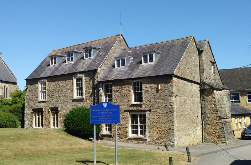
BRACKLEY HIGH STREET 1. 5328 (East Side) Magdalen College School, Building to south of Chapel of Saints John and James SP 5836 1/36 22.4.50. II GV 2. A building standing back from the road and to the north-east of that mentioned above, it consists of the remains of a probably C16-17 house which has been altered and added to. 2-storeyed coursed rubble with Welsh slate roof. The south gable end has a massive projecting stone stack with stepped Welsh slated offsets; the north-east end gable has a smaller projecting stone stack and both have moulded brick shafts. In the west front are modern sash windows, one with 3 C19 Gothic traceried lights. The 1st floor north windows in the west front are in stone keystoned C18 frames. (See Jnl. Brit. Arch. Assoc., III (1938), 200).
Listing NGR: SP5859136958
External links are from the relevant listing authority and, where applicable, Wikidata. Wikidata IDs may be related buildings as well as this specific building. If you want to add or update a link, you will need to do so by editing the Wikidata entry.


Other nearby listed buildings