Latitude: 55.109 / 55°6'32"N
Longitude: -1.667 / 1°40'1"W
OS Eastings: 421339
OS Northings: 579451
OS Grid: NZ213794
Mapcode National: GBR J9SC.WC
Mapcode Global: WHC2Y.CVD7
Plus Code: 9C7W485M+J5
Entry Name: Bus Shelter 45 Metres North of Footbridge
Listing Date: 29 April 1987
Grade: II
Source: Historic England
Source ID: 1042661
English Heritage Legacy ID: 238971
ID on this website: 101042661
Location: Stannington, Northumberland, NE61
County: Northumberland
Civil Parish: Stannington
Built-Up Area: Stannington
Traditional County: Northumberland
Lieutenancy Area (Ceremonial County): Northumberland
Church of England Parish: Stannington St Mary the Virgin
Church of England Diocese: Newcastle
Tagged with: Bus shelter
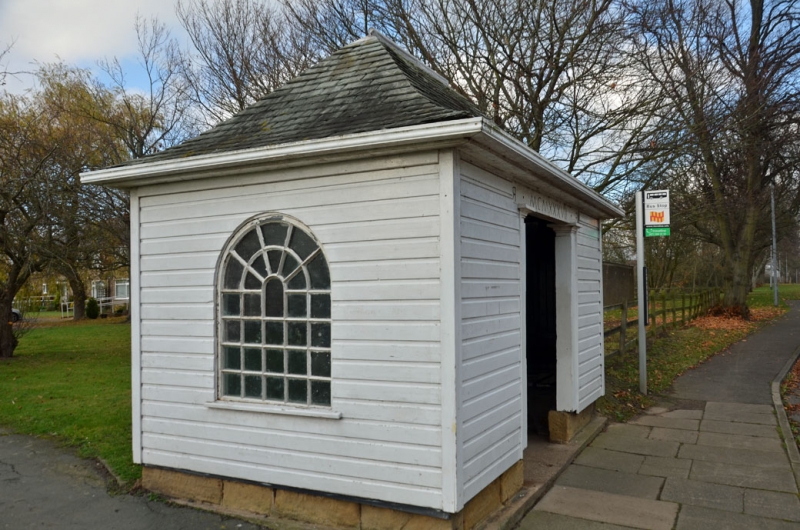
STANNINGTON AI (West side)
NZ 27 NW
Stannington
8/55 Bus shelter
45 metres north
of footbridge
GV II
Bus shelter, dated 1937, by Laurence Whistler. Wood on squared stone plinth;
Lakeland slate roof. Central opening flanked by Tuscan pilasters, with date in
Roman numerals on lintel between opposed Rs. Horizontally-panelled walls,
moulded eaves cornice. Swept hipped roof. Left return shows iron-framed
casement with radial and concentric glazing bars under round arch.
One of a pair presented to the village by Lord Ridley to commemorate the
coronation of King George VI.
Listing NGR: NZ2133979451
External links are from the relevant listing authority and, where applicable, Wikidata. Wikidata IDs may be related buildings as well as this specific building. If you want to add or update a link, you will need to do so by editing the Wikidata entry.


Other nearby listed buildings