Latitude: 53.4113 / 53°24'40"N
Longitude: -0.9616 / 0°57'41"W
OS Eastings: 469122
OS Northings: 390999
OS Grid: SK691909
Mapcode National: GBR PXQZ.MW
Mapcode Global: WHFFW.6JC6
Plus Code: 9C5XC26Q+G9
Entry Name: Davenport House and Boundary Wall
Listing Date: 23 November 1984
Grade: II
Source: Historic England
Source ID: 1045093
English Heritage Legacy ID: 241098
ID on this website: 101045093
Location: Everton, Bassetlaw, Nottinghamshire, DN10
County: Nottinghamshire
District: Bassetlaw
Civil Parish: Everton
Built-Up Area: Everton
Traditional County: Nottinghamshire
Lieutenancy Area (Ceremonial County): Nottinghamshire
Church of England Parish: Everton
Church of England Diocese: Southwell and Nottingham
Tagged with: Building
SK 69 SE EVERTON BAWTRY ROAD (south side)
4/14 Davenport House and boundary wall
II
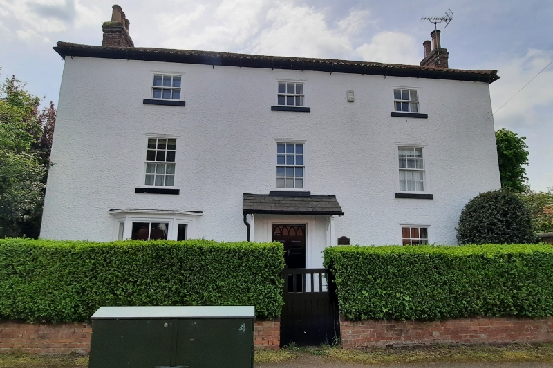
House, late C18 and C19, brick, pebble dashed, with C20 hipped pantile roof. Rendered plinth, stone sills, dentillated eaves, 2 sidewall stacks, 3 storeys, 3 bays. L plan. Front has central early C20 open timber porch with pitched slate roof, moulded timber doorcase with patarae, modillioned cornice and Adam style decoration; overlight with Gothic tracery. C19 6 panel half- glazed door. Flanked to left by C19 canted timber bay window with 3 plain sashes, and to right by single glazing bar sash. Above, 3 glazing bar sashes on each floor. Additional C19 rear wing has hipped pantiled roof and one gable stack. Outside, brick boundary wall to Mattersey Road, stone coping panels and 14 intermediate brick buttresses, approx 60 m long.
Listing NGR: SK6912290999
External links are from the relevant listing authority and, where applicable, Wikidata. Wikidata IDs may be related buildings as well as this specific building. If you want to add or update a link, you will need to do so by editing the Wikidata entry.


Other nearby listed buildings