Latitude: 53.1107 / 53°6'38"N
Longitude: -0.9913 / 0°59'28"W
OS Eastings: 467616
OS Northings: 357532
OS Grid: SK676575
Mapcode National: GBR 9H5.VKY
Mapcode Global: WHFHD.R24L
Plus Code: 9C5X4265+7F
Entry Name: Highfield Farmhouse
Listing Date: 26 October 1973
Last Amended: 13 May 1986
Grade: II
Source: Historic England
Source ID: 1045493
English Heritage Legacy ID: 242175
ID on this website: 101045493
Location: Kirklington, Newark and Sherwood, Nottinghamshire, NG22
County: Nottinghamshire
District: Newark and Sherwood
Civil Parish: Kirklington
Built-Up Area: Kirklington
Traditional County: Nottinghamshire
Lieutenancy Area (Ceremonial County): Nottinghamshire
Church of England Parish: Kirklington
Church of England Diocese: Southwell and Nottingham
Tagged with: Farmhouse
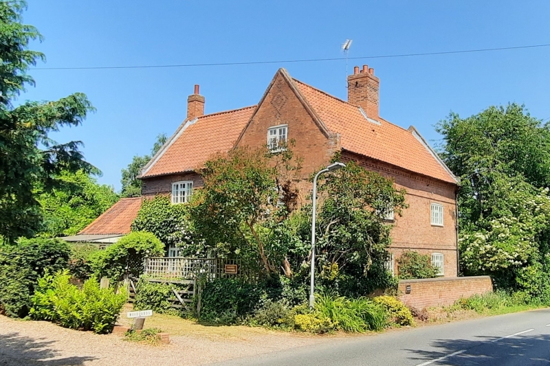
SK 65 NE KIRKLINGTON SOUTHWELL ROAD
(west side)
3/120 Highfield Farmhouse (formerly
listed under Mill Lane)
26.10.73
II
Farmhouse. Early C18. Red brick, some blue brick. Pantile
roof. Single central ridge red brick stack. Raised brick coped
gables with kneelers. Dentil, raised brick and dogtooth eaves.
First floor band and band over first floor lintels. L-plan. 2
storeys plus garret, 2 bays. 2 tripartite glazing bar casements
with 2 similar casements above, all under segmental arches and
flanked by single C20 shutters. Over the garret window of the
left gable is some blue brick diaper. Wing to rear with similar
gable.
Listing NGR: SK6761657532
External links are from the relevant listing authority and, where applicable, Wikidata. Wikidata IDs may be related buildings as well as this specific building. If you want to add or update a link, you will need to do so by editing the Wikidata entry.


Other nearby listed buildings