Approximate Location Map
Large Map »
Latitude: 53.3895 / 53°23'22"N
Longitude: -1.1177 / 1°7'3"W
OS Eastings: 458773
OS Northings: 388437
OS Grid: SK587884
Mapcode National: GBR NYM7.TP
Mapcode Global: WHDDV.S2YC
Plus Code: 9C5W9VQJ+RW
Entry Name: Goldthorpe Mill
Listing Date: 12 April 1985
Last Amended: 1 November 2002
Grade: II
Source: Historic England
Source ID: 1045722
English Heritage Legacy ID: 241430
ID on this website: 101045722
Location: Oldcotes, Bassetlaw, Nottinghamshire, S81
County: Nottinghamshire
District: Bassetlaw
Civil Parish: Hodsock
Built-Up Area: Oldcotes
Traditional County: Nottinghamshire
Lieutenancy Area (Ceremonial County): Nottinghamshire
Church of England Parish: Langold with Oldcotes
Church of England Diocese: Southwell and Nottingham
Tagged with: Mill
HODSOCK
399/2/76 DONCASTER ROAD
12-APR-1985 Oldcotes
(West side)
GOLDTHORPE MILL
II
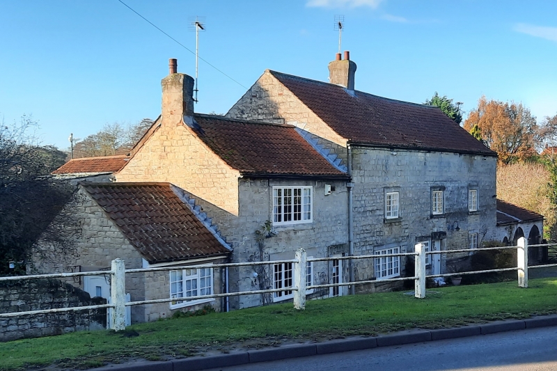
House, formerly water-mill. Early C18 with later C18, C19 and C20 alterations and additions. Dressed coursed rubble. Pantile roof. Single rendered ridge stack and large brick rear wall stack. Ground floor ashlar band, broken by a single window. 2 storeys plus garret, 4 bays, with evidence of heightening above the first floor windows.
Doorway with stable door and rock-faced stone surround. To the right is a single glazing bar Yorkshire sash with similar surround. To the left a single C20 glazing bar casement with stone lintel and left stone jamb. Further left is a single large 4-light glazing bar casement breaking out of the original opening with remains of the right stone jamb. Above are three 2-light glazing bar Yorkshire sashes in rough stone surrounds. All windows originally had stone mullions. In the garrets are single 2-light glazing bar casements with rough stone surrounds and single stone mullions.
To the right is a single storey dressed coursed rubble and pantile. 3 bay wing with segment arched doorway with wooden door, and to its right 2 large arched opening with double plank doors.
To the left is a 2 storey 2 bay, dressed coursed rubble and pantile. Late C18 extension with ground floor sill band. Having a doorway with C20 glazed door and rough stone surround, to its left is a single large glazing bar casement with
similar stone jambs and concrete lintel. Above is a similar casement with rough stone surround. Below the ground floor window is a Ordnance Survey 'sea-level' mark. To the left, set back, is a single storey, single bay, dressed coursed rubble and pantile C20 extension, with single casement.
The rear left has a single glazing bar casement with rough stone surround and a large blocked doorway with similar surround, now containing a small wooden door. Above is a single glazing bar casement with similar surround. To the right are various C18 and C19 extensions.
INTERIOR; mill still retains a late C19 steel waterwheel and remnants of the earlier wooden gear wheels and power transmission. Some rooms retain chamfered wooden spine beams.
Listing NGR: SK5877388437
External links are from the relevant listing authority and, where applicable, Wikidata. Wikidata IDs may be related buildings as well as this specific building. If you want to add or update a link, you will need to do so by editing the Wikidata entry.


Other nearby listed buildings
