Approximate Location Map
Large Map »
Latitude: 53.3476 / 53°20'51"N
Longitude: -1.1179 / 1°7'4"W
OS Eastings: 458817
OS Northings: 383769
OS Grid: SK588837
Mapcode National: GBR NYMQ.RQ
Mapcode Global: WHDF1.S4V1
Plus Code: 9C5W8VXJ+2R
Entry Name: Barn, Pigeoncote and Attached Outbuildings at Low Field Farm
Listing Date: 12 April 1985
Grade: II
Source: Historic England
Source ID: 1045738
English Heritage Legacy ID: 241368
ID on this website: 101045738
Location: South Carlton, Bassetlaw, Nottinghamshire, S81
County: Nottinghamshire
District: Bassetlaw
Civil Parish: Carlton in Lindrick
Built-Up Area: Carlton in Lindrick
Traditional County: Nottinghamshire
Lieutenancy Area (Ceremonial County): Nottinghamshire
Church of England Parish: Carlton-in-Lindrick
Church of England Diocese: Southwell and Nottingham
Tagged with: Barn
SK 58 SE CARLTON-IN-LINDRICK CHURCH LANE
South Carlton
(South side)
4/12 Barn, pigeoncote
and attached out-
buildings at
Low Field Farm
G.V. II
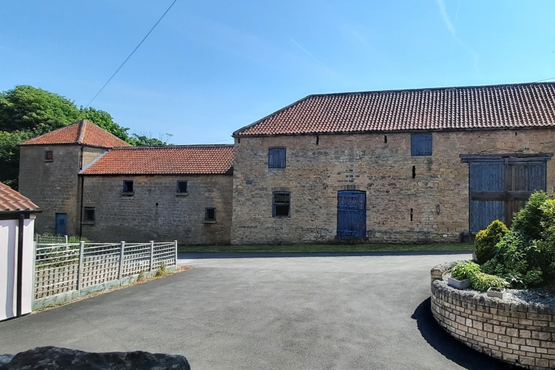
Barn, pigeoncote and attached outbuildings. Early C19. Dressed
coursed rubble with pantile roofs. 2 storey barn with hipped
roof. Large blocked carriage arch now containing a small wooden
door under a segmental arch. To the left is a single, small
slatted opening with glazing bar overlight under a segmental arch
and a further doorway. To the right are 2 doorways with stable
doors under segmental arches. There are 2 slit ventilators and 3
round tie plates. To the right is a one and a half storey, 5
bay, outbuilding with eaves band. 4 doorways with wooden doors.
Above are 3 lights, 2 being fixed and one blocked. All openings
have flush splayed lintels. To the right is a 2 storey
pigeoncote with pyramidal roof and eaves band. Doorway with
wooden stable door, above is a single boarded opening.
Projecting from this is a single storey, 5 bay, cart shed and
outbuilding of red brick, dressed coursed rubble with hipped roof
to the right. With various altered openings and extensions. The
rear wall of dressed coursed rubble fronts the street. Included
for group value only.
Listing NGR: SK5880183770
External links are from the relevant listing authority and, where applicable, Wikidata. Wikidata IDs may be related buildings as well as this specific building. If you want to add or update a link, you will need to do so by editing the Wikidata entry.


Other nearby listed buildings
