Approximate Location Map
Large Map »
Latitude: 53.1801 / 53°10'48"N
Longitude: -0.8057 / 0°48'20"W
OS Eastings: 479913
OS Northings: 365442
OS Grid: SK799654
Mapcode National: GBR CK9.M3L
Mapcode Global: WHFH3.LBJF
Plus Code: 9C5X55JV+2P
Entry Name: Sutton Windmill
Listing Date: 19 September 1985
Grade: II
Source: Historic England
Source ID: 1045967
English Heritage Legacy ID: 242822
ID on this website: 101045967
Location: Sutton on Trent, Newark and Sherwood, Nottinghamshire, NG23
County: Nottinghamshire
District: Newark and Sherwood
Civil Parish: Sutton-on-Trent
Built-Up Area: Sutton on Trent
Traditional County: Nottinghamshire
Lieutenancy Area (Ceremonial County): Nottinghamshire
Church of England Parish: Sutton-upon-Trent
Church of England Diocese: Southwell and Nottingham
Tagged with: Building
SK 76 NE SUTTON ON TRENT MAIN STREET
(west side)
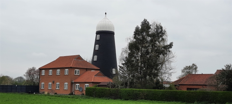
1/118 Sutton Windmill
II
Windmill. c.1814. Brick, tarred. Stepped brick plinth, cogged
and rebated eaves. Round battered tower, 5 stages. Windows are
unglazed, with segmental heads. First stage has door to east
with segmental head. Each stage has a single window to north and
south. Interior has main structural timbers.
Listing NGR: SK7991365442
External links are from the relevant listing authority and, where applicable, Wikidata. Wikidata IDs may be related buildings as well as this specific building. If you want to add or update a link, you will need to do so by editing the Wikidata entry.


Other nearby listed buildings
