Approximate Location Map
Large Map »
Latitude: 51.7325 / 51°43'57"N
Longitude: -1.2292 / 1°13'44"W
OS Eastings: 453330
OS Northings: 204036
OS Grid: SP533040
Mapcode National: GBR 8ZC.82Z
Mapcode Global: VHCXV.NQ17
Plus Code: 9C3WPQMC+28
Entry Name: Stone on the South West Side of Rose Hill at the North East Corner of Denton House Boundary Wall
Listing Date: 28 June 1972
Grade: II
Source: Historic England
Source ID: 1046588
English Heritage Legacy ID: 245254
ID on this website: 101046588
Location: Iffley, Oxford, Oxfordshire, OX4
County: Oxfordshire
District: Oxford
Electoral Ward/Division: Rose Hill and Iffley
Parish: Non Civil Parish
Built-Up Area: Oxford
Traditional County: Oxfordshire
Lieutenancy Area (Ceremonial County): Oxfordshire
Church of England Parish: Iffley
Church of England Diocese: Oxford
Tagged with: Building Boundary marker
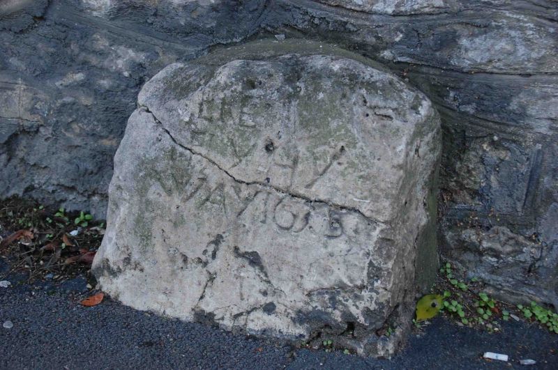
INSCRIBED STONES
1.
1485
Highway stones
Stone on the South-West
Side of Rose Hill at
the North-East corner of
Denton House boundary wall
SP 50 SW 26/745
II
2.
Stone inscribed "- ere - Ifily Hy Way 1635". This was the main road to London
via Henley.
Listing NGR: SP5333004036
External links are from the relevant listing authority and, where applicable, Wikidata. Wikidata IDs may be related buildings as well as this specific building. If you want to add or update a link, you will need to do so by editing the Wikidata entry.


Other nearby listed buildings
