Approximate Location Map
Large Map »
Latitude: 51.7315 / 51°43'53"N
Longitude: -1.2358 / 1°14'8"W
OS Eastings: 452874
OS Northings: 203922
OS Grid: SP528039
Mapcode National: GBR 8ZC.DD3
Mapcode Global: VHCXV.JQKZ
Plus Code: 9C3WPQJ7+JM
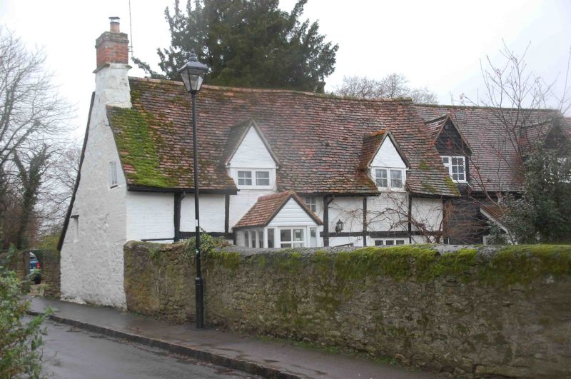
Entry Name: Tudor Cottage
Listing Date: 28 June 1972
Grade: II
Source: Historic England
Source ID: 1047316
English Heritage Legacy ID: 245385
ID on this website: 101047316
Location: Iffley, Oxford, Oxfordshire, OX4
County: Oxfordshire
District: Oxford
Electoral Ward/Division: Rose Hill and Iffley
Parish: Non Civil Parish
Built-Up Area: Oxford
Traditional County: Oxfordshire
Lieutenancy Area (Ceremonial County): Oxfordshire
Church of England Parish: Iffley
Church of England Diocese: Oxford
Tagged with: Cottage
CHURCH WAY
1.
1485
(West Side)
No 56
(Tudor Cottage)
SP 5203 NE 14/699
II
2.
C16/C17. Timber framed with brick infill and rubble gable end. 1 storey
and attic. 2 tripartite casements and gabled porch below; 2 gabled casement
dormers above. Tiled roof.
Listing NGR: SP5287403922
External links are from the relevant listing authority and, where applicable, Wikidata. Wikidata IDs may be related buildings as well as this specific building. If you want to add or update a link, you will need to do so by editing the Wikidata entry.


Other nearby listed buildings
