Approximate Location Map
Large Map »
Latitude: 52.0376 / 52°2'15"N
Longitude: -1.4876 / 1°29'15"W
OS Eastings: 435245
OS Northings: 237817
OS Grid: SP352378
Mapcode National: GBR 6RP.8Q1
Mapcode Global: VHBYX.51FS
Plus Code: 9C4W2GQ6+3X
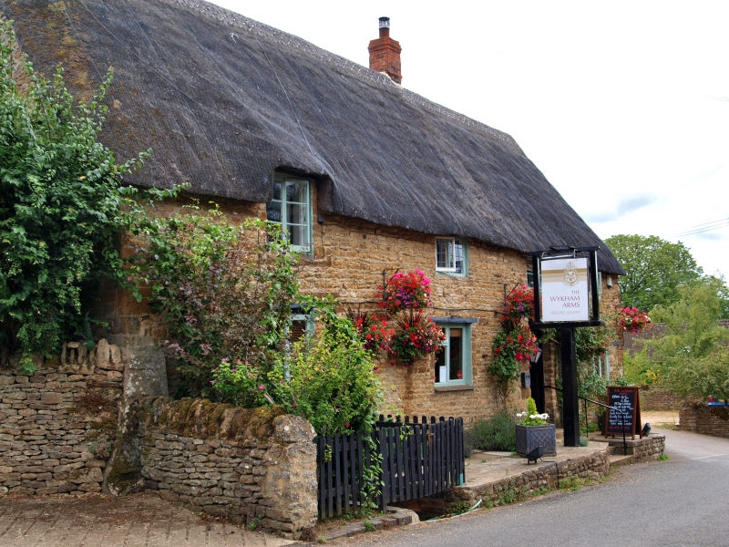
Entry Name: The Wykham Arms Public House
Listing Date: 20 September 1988
Grade: II
Source: Historic England
Source ID: 1046801
English Heritage Legacy ID: 244731
Also known as: The Wykham Arms, Banbury
Wykham Arms
ID on this website: 101046801
Location: Sibford Gower, Cherwell, Oxfordshire, OX15
County: Oxfordshire
District: Cherwell
Civil Parish: Sibford Gower
Built-Up Area: Sibford Gower
Traditional County: Oxfordshire
Lieutenancy Area (Ceremonial County): Oxfordshire
Church of England Parish: Sibford
Church of England Diocese: Oxford
Tagged with: Pub Thatched pub
SIBFORD GOWER HOOK NORT0N ROAD
SP3436-3536
(East side)
16/174 The Wykham Arms Public House
05/12/84
II
Possibly originally a farmhouse now public house. C17 with later alterations.
Coursed ironstone rubble. Steeply pitched thatched roof. Brick ridge and end
stacks. 3-unit plan plus rear range forming L-plan. 2 storeys. 4-window range.
Entrance to right has C20 door with overlight and wood lintel. Ground floor has
three 2-light wood casements with wood lintels. First floor has a half-dormer
window with small casement and 3 small 2-light casements, most with lead cames
and wrought-iron fasteners. Interior has wide inglenook fireplace with chamfered
bressumer, stop-chamfered beam and stop-chamfered joists.
(VCH: Oxfordshire: Vol X, p228)
Listing NGR: SP3524537817
External links are from the relevant listing authority and, where applicable, Wikidata. Wikidata IDs may be related buildings as well as this specific building. If you want to add or update a link, you will need to do so by editing the Wikidata entry.


Other nearby listed buildings
