Approximate Location Map
Large Map »
Latitude: 52.0604 / 52°3'37"N
Longitude: -1.3387 / 1°20'19"W
OS Eastings: 445433
OS Northings: 240425
OS Grid: SP454404
Mapcode National: GBR 7ST.Y2P
Mapcode Global: VHCW7.RG4W
Plus Code: 9C4W3M66+4G
Entry Name: The Banbury Barbeque
Listing Date: 8 July 1975
Last Amended: 14 February 1986
Grade: II
Source: Historic England
Source ID: 1046941
English Heritage Legacy ID: 244363
ID on this website: 101046941
Location: Banbury, Cherwell, Oxfordshire, OX16
County: Oxfordshire
District: Cherwell
Civil Parish: Banbury
Built-Up Area: Banbury
Traditional County: Oxfordshire
Lieutenancy Area (Ceremonial County): Oxfordshire
Church of England Parish: Banbury St Mary
Church of England Diocese: Oxford
Tagged with: Building
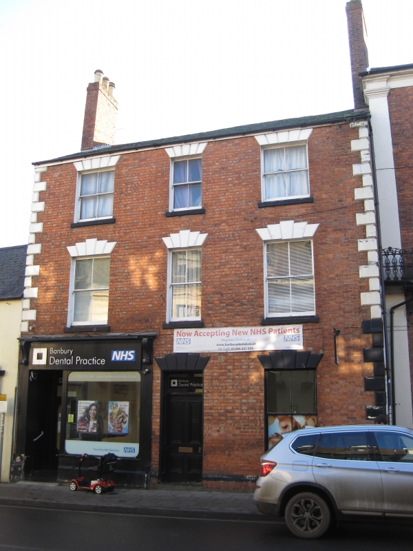
BANBURY HIGH STREET
SP4540SW (South side)
9/69 Nos.35 (The Banbury Barbeque)
08/07/75 and 35A
(Formerly listed as Nos.35 and
35A)
GV II
House, now shop and house. Mid C19. Brick, slate roof, brick end stacks. 3
storeys; 3-window range altogether. 2 entrances. Central entrance has a
4-panelled door with overlight. Entrance to left has glazed door and shop front
with C19 cast-iron canopy above. Plain window to right. 3 sashes to first floor
have stone sills (4 panes altogether). 3 similar windows to second floor. All
windows have keystoned voussoirs and sashes are horned. Rusticated stone quoins.
Interior to right part (35A): dog-leg staircase. Rear brick extension has fire
proofed record room on first floor.
Listing NGR: SP4543740424
External links are from the relevant listing authority and, where applicable, Wikidata. Wikidata IDs may be related buildings as well as this specific building. If you want to add or update a link, you will need to do so by editing the Wikidata entry.


Other nearby listed buildings
