Approximate Location Map
Large Map »
Latitude: 51.7572 / 51°45'25"N
Longitude: -1.2603 / 1°15'37"W
OS Eastings: 451152
OS Northings: 206755
OS Grid: SP511067
Mapcode National: GBR 8YY.S6J
Mapcode Global: VHCXV.33L9
Plus Code: 9C3WQP4Q+VV
Entry Name: 50 and 51, St Giles Street
Listing Date: 12 January 1954
Grade: II
Source: Historic England
Source ID: 1047106
English Heritage Legacy ID: 245845
ID on this website: 101047106
Location: Norham Manor, Oxford, Oxfordshire, OX1
County: Oxfordshire
District: Oxford
Electoral Ward/Division: Carfax
Parish: Non Civil Parish
Built-Up Area: Oxford
Traditional County: Oxfordshire
Lieutenancy Area (Ceremonial County): Oxfordshire
Church of England Parish: Oxford St Giles
Church of England Diocese: Oxford
Tagged with: Building
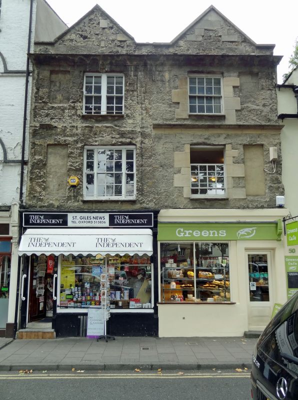
ST GILES' STREET
1.
1485
(West Side)
Nos 50 & 51
SP 5106 NW 5/517 12.1.54.
II GV
2.
House and shops. 2 houses in one building. RCHM 177. A late C18 front
on a probably early Cl7 core. 3-storeyed ashlar and timber-framed building,
partly plastered on the front, with cellars, moulded string and a moulded
parapet, above which are 2 plastered gables and a Welsh slate roof. There
are shop fronts in the ground floor. On each side of the front in the 1st
and 2nd floors are tall blocked sash windows. No 50 has a C19 sash window
in both floors. No 51 has a 1st floor 3-light sash and a 2nd floor 2-light
sash window. At the back the wing has been rebuilt in red brick on the ground
floor and the 1st floor appears to be original. Interior: RCHM page 178b.
Includes an original moulded wall post and some C18 fireplaces.
Nos 31 to 46 (consec) and Nos 49 to 96 (consec) form a group.
Listing NGR: SP5114906757
External links are from the relevant listing authority and, where applicable, Wikidata. Wikidata IDs may be related buildings as well as this specific building. If you want to add or update a link, you will need to do so by editing the Wikidata entry.


Other nearby listed buildings
