Approximate Location Map
Large Map »
Latitude: 51.7545 / 51°45'16"N
Longitude: -1.2672 / 1°16'1"W
OS Eastings: 450680
OS Northings: 206456
OS Grid: SP506064
Mapcode National: GBR 7XL.Y65
Mapcode Global: VHCXT.Z5GB
Plus Code: 9C3WQP3M+R4
Entry Name: Rewley Abbey, Wall and Gateway
Listing Date: 12 January 1954
Grade: II
Source: Historic England
Source ID: 1047151
English Heritage Legacy ID: 245756
ID on this website: 101047151
Location: Jericho, Oxford, Oxfordshire, OX1
County: Oxfordshire
District: Oxford
Electoral Ward/Division: Jericho and Osney
Parish: Non Civil Parish
Built-Up Area: Oxford
Traditional County: Oxfordshire
Lieutenancy Area (Ceremonial County): Oxfordshire
Church of England Parish: Oxford St Barnabas with St Thomas the Martyr
Church of England Diocese: Oxford
Tagged with: Building
REWLEY ROAD
1.
1485
(North Side)
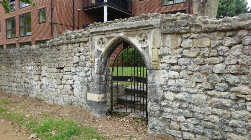
Rewley Abbey,
wall & gateway
SP 5006 SE 7/610 12.1.54.
II
2.
Facing onto the South-West side of the Oxford Canal. A Cistercian foundation
of 1281. All the buildings have been destroyed except a short length of
wall in which is a C15 stone doorway; it has a 2-centred arch in a square
head with spandrels in which are quatrefoils; there is a label above with
stops and the jambs are moulded. For its state in 1820 see two drawings
by J C Buckler in Bodl. MS. Don. a. 3. II, 120 and 121.
Listing NGR: SP5068006456
External links are from the relevant listing authority and, where applicable, Wikidata. Wikidata IDs may be related buildings as well as this specific building. If you want to add or update a link, you will need to do so by editing the Wikidata entry.


Other nearby listed buildings
